


501-918-3025
calsfoundation@cals.org
calsfoundation@cals.org
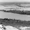
Big Rock is the name now given to a 200-foot bluff located on the north bank of the Arkansas River in North Little Rock (Pulaski County). It is the first major outcrop of rock along the river, 121 miles upstream from the confluence of the Arkansas and Mississippi rivers and about two miles upstream from a smaller outcrop known as the Little Rock, where the capital city of Arkansas developed.
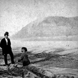
The first European to record the bluffs was French explorer Jean-Baptiste Bénard de La Harpe on April 9, 1722, when he took possession in the name of the French king, Louis XIV. His journal records that he named it “Le Rocher Français” (“French Rock”) and described it as having three steep peaks, with stone “hard as flint,” and a waterfall and slate quarries nearby.
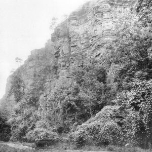
The bluff is composed predominantly of sandstone and shale of the Jackfork Formation (Pennsylvanian period) and marks the transition from the Delta plains to the Ouachita Mountains. The top of the ridge is approximately half a mile wide (northwest to southeast), and the south face extends approximately one mile east-west along the river. Its location was significant in early state history, close to the two main arteries of travel: the Arkansas River itself and the Southwest Trail leading overland from St. Louis to Santa Fe via the Red River country. Downstream, at the Little Rock, it was possible to ford the river, and a settlement developed there. The name “Petit Rocher” (“Little Rock”) appears on a 1799 French map of the area, and by the early 1800s, the English term was in general use to refer to one of the boundaries of land open for settlement. In 1814, the township of Big Rock was created, one of nine in the newly formed Arkansas County. An August 20, 1822, article in the Arkansas Gazette distinguishes between the two rock formations.
One of the earliest recorded settlers in the vicinity of Big Rock was Wright Daniel (1814). He was visited in 1819 by Thomas Nuttall, who noted settlers of Quapaw and French descent on Spanish land grants on the north bank. In 1847, the Shillcutt family owned farmland and woods along the bayou on the north base of the ridge. Settlement around Big Rock was sparse, since the north bank was generally lower than the south bank and prone to flooding.
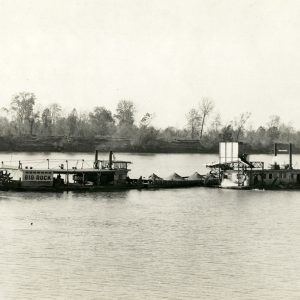
A quarry on the south face of the ridge was in operation in 1849, when Roswell Beebe advertised “sufficient stone (in it) to build a city.” Rock continued to be mined for over a century, used mainly for railway ballast. An estimated 20,000,000 tons were removed in fifty years of mining by Big Rock Stone & Material Company. The sixty-four-acre area is now owned by the City of North Little Rock.
By 1870, part of the top of the ridge was under cultivation as a vineyard and orchards. In 1887, Mountain Park Hotel opened there as a summer resort. This was acquired by the federal government in 1893 for one of twelve new military installations in the country, and Fort Logan H. Roots was opened in April 1897. Many of the original buildings are on the National Register of Historic Places. Still known locally as Fort Roots, its official title is now the North Little Rock Regional Office of the Central Arkansas Veterans Healthcare System, which operates the Eugene J. Towbin Healthcare Center there.
At the west end of the ridge is University of Arkansas-Pulaski Technical College in the Scenic Hills neighborhood. It opened in January 1976, built on forty acres of government surplus land transferred to the North Little Rock School District in the early 1970s. The parkland at the southwest corner (also surplus government land) is named Emerald Park. It included, until it closed in 2014, a nine-hole golf course, and its walking and cycle trails are part of the Northshore River Trail extending from downtown North Little Rock to the west end of Big Rock. Although officially the name was chosen to reflect the beauty of the surrounding country, it also alludes to the fabled jewel-encrusted rock early explorers dreamed of finding.
For additional information:
Adams, Walter M. North Little Rock, the Unique City: A History. Little Rock: August House, 1986.
———. “The Railroads of North Little Rock.” Unpublished manuscript, 1980. North Little Rock History Commission, North Little Rock, AR.
Bradburn, Cary. On the Opposite Shore: The Making of North Little Rock. Marceline, MO: Walsworth Publishing Company, 2004.
History of Fort Roots: Old to New. North Little Rock, AR: Veterans Administration Medical Center, 1983.
Richards, Ira Don. Story of a Rivertown: Little Rock in the Nineteenth Century. Benton, AR: 1969.
Riley, Thomas A., Alice Barton, and Donna Simon. North Little Rock: A Pictorial History. North Little Rock, AR: North Little Rock Times, 1991.
Ross, Margaret. “20,000,000 Tons.” Arkansas Gazette. September 11, 1955, p. 1F.
Roy, F. Hamilton, and Charles Witsell. How We Lived: Little Rock as an American City. Little Rock: August House, 1984.
Kate Buck
Little Rock, Arkansas


Comments
No comments on this entry yet.