501-918-3025
calsfoundation@cals.org
calsfoundation@cals.org
| Latitude and Longitude: | 35°13’18″N 090°12’20″W |
|---|---|
| Elevation: | 220 feet |
| Area: | 0.26 square miles (2020 Census) |
| Population: | 184 (2020 Census) |
| Incorporation Date: | February 4, 1970 |
Historical Population as per the U.S. Census:
|
1810 |
1820 |
1830 |
1840 |
1850 |
1860 |
1870 |
1880 |
1890 |
1900 |
|---|---|---|---|---|---|---|---|---|---|
|
– |
– |
– |
– |
– |
– |
– |
– |
– |
– |
|
1910 |
1920 |
1930 |
1940 |
1950 |
1960 |
1970 |
1980 |
1990 |
2000 |
|
– |
– |
– |
– |
– |
– |
– |
582 |
571 |
348 |
|
2010 |
2020 |
|
|
|
|
|
|
|
|
|
198 |
184 |
|
|
|
|
|
|
|
|
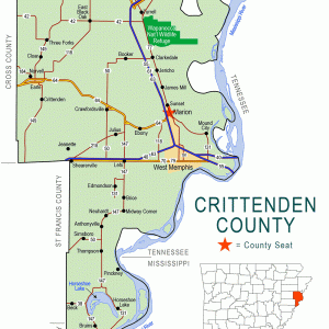
Sunset is a largely African-American town north of Marion (Crittenden County) and adjacent to Interstate 55. A school building in Sunset is on the National Register of Historic Places.
Quapaw lived in the area before European explorers first visited. Two Spanish land grants were bestowed before 1800 for the land where Sunset would be built. The land became part of the United States with the Louisiana Purchase in 1803. Cotton was grown on the land both before and after the Civil War.
Many former slaves continued to live as tenant farmers in Crittenden County after the Civil War. Friendship Lodge No. 39, a Masonic association for African Americans, was organized in 1873. A school for African-American children was built in 1924 with money provided by the Julius Rosenwald Fund. The Marion Colored High School served children from Marion and the surrounding area through the eighth grade; high school classes were added in 1937, with families required to pay eight dollars a year until 1943. The original Rosenwald building became the high school when a new elementary school for African Americans was built next door in 1955. Streets and homes were built around the school, and the community became known as the Sunset Subdivision of Marion.
Only a few businesses developed in Sunset—two cotton gins, a funeral home, and some stores and cafes. There was also a lamp-manufacturing firm founded in 1963 by M. L. Pike Jr. The plant burned in 1973 and was rebuilt, but as the company grew, it built a larger plant south of Marion. Several doctors lived in Sunset, as did James Sebastian Phelix, a land investor who was active in the Masonic organization. A volunteer fire department was organized for Sunset in 1967; most of its members were teenaged boys.
Crittenden County schools were desegregated in 1970, and the Rosenwald school building was no longer needed. The elementary school continued to be used for classes, now serving both white and Black children. Occasionally, the elementary school used the high school building for special events. The Rosenwald school was officially designated the Marion Colored High School, but locally it was known as the Phelix High School. It was added to the National Register of Historic Places on March 23, 1995.
The subdivision received city services from Marion, but Sunset incorporated as a town in 1970 and began to seek federal funding to provide water and sewer services. Sewer service became available in 1978. When it incorporated, Sunset had about 450 residents, most of whom were African American. The population remained above 500 during the 1980s and 1990s. By the 2000 census, the population had declined to 348, and the next decade saw it fall to 198.
Sunset is home to three Missionary Baptist churches and a Church of God in Christ. Some businesses are located on the interstate’s access road on the west end of the town, and a county recycling plant is located on land north of town that was annexed by Sunset in 1981. The town also opened a park in 1981. Sunset does not have a post office; Sunset residents receive their mail through Marion’s post office.
For additional information:
“Marion Colored High School.” National Register of Historic Places nomination form. On file at Arkansas Historic Preservation Program, Little Rock, Arkansas. Online at https://www.arkansasheritage.com/docs/default-source/national-registry/ct0088-pdf.pdf?sfvrsn=1d4a56e6_0 (accessed February 8, 2026).
Woolfolk, Margaret Elizabeth. A History of Crittenden County, Arkansas. Greenville, SC: Southern Historical Press Inc., 1991.
Steven Teske
Butler Center for Arkansas Studies


Comments
No comments on this entry yet.