501-918-3025
calsfoundation@cals.org
calsfoundation@cals.org
| Latitude and Longitude: | 36°23’41″N 092°54’39″W |
|---|---|
| Elevation: | 840 feet |
| Area: | 0.16 square miles (2020 Census) |
| Population: | 86 (2020 Census) |
| Incorporation Date: | May 25, 1970 |
Historical Population as per the U.S. Census:
|
1810 |
1820 |
1830 |
1840 |
1850 |
1860 |
1870 |
1880 |
1890 |
1900 |
|---|---|---|---|---|---|---|---|---|---|
|
– |
– |
– |
– |
– |
– |
– |
– |
– |
– |
|
1910 |
1920 |
1930 |
1940 |
1950 |
1960 |
1970 |
1980 |
1990 |
2000 |
|
– |
– |
– |
– |
– |
– |
– |
85 |
86 |
88 |
|
2010 |
2020 |
|
|
|
|
|
|
|
|
|
102 |
86 |
|
|
|
|
|
|
|
|
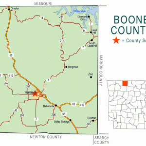
South Lead Hill is a residential town located on State Highway 7 in northern Boone County. It is one of three communities that formed after the construction of Bull Shoals Dam flooded the location of the earlier town of Lead Hill (Boone County).
Osage hunted and fished in northern Arkansas before the Louisiana Purchase added the land to the United States in 1803. A series of treaties moved the Osage west to Indian Territory (now the state of Oklahoma), but the northern part of Arkansas Territory remained sparsely settled for many years. Eli Dodson and William Cantrell both acquired land patents east of the location that would become South Lead Hill in 1854. In 1884, Robert Hollis purchased the land on which the town itself would be built.
By that time, the town of Lead Hill was flourishing, with a Baptist church, a hotel, and a newspaper. Residents of Lead Hill included six merchants, four doctors, two blacksmiths, two preachers, a seamstress, a cabinet maker, a druggist, a carpenter, a miller, and a shoemaker. Early in the twentieth century, a Methodist church and a Christian Church (Disciples of Christ) congregation were formed in Lead Hill. A Baptist congregation was later established. School consolidation in Boone County, under the leadership of William Erwin Halbrook, reduced the county’s almost 100 school districts to eight, including the Lead Hill School District, which acquired students from eight smaller school districts in the region.
In 1938, the Flood Control Act called for dams on the White River. Due to World War II and the construction of Norfork Dam, construction of Bull Shoals Dam near the Baxter and Marion county line did not begin until 1947. The dam, which was dedicated in 1952, created a lake that extends into Boone County and also north into Missouri. The new lake inundated much prosperous farmland in Boone County, as well as the towns of Dubuque (Boone County) and Lead Hill. Many historic structures were destroyed, including homes, the church, and the cotton gin. Some buildings were moved, but residents were divided about where to relocate. Some chose a hill several miles from the original location of Lead Hill, and that community preserved the original name of the town. Others chose to build on the shore of the new lake, and their town became known as Diamond City (Boone County). A few families chose a location a bit south of the relocated Lead Hill, and they named their town South Lead Hill.
A dedication ceremony was held on March 9, 1950, to promote South Lead Hill. Free lots were offered to churches, and stores, theaters, and residential areas were planned. The Baptist congregation of Lead Hill divided into two churches, one of which was built in South Lead Hill. A Pentecostal congregation built a church building between Lead Hill and South Lead Hill. The town of South Lead Hill was incorporated in 1970. The town has never had a post office.
At the time of the 2010 census, the population of South Lead Hill was 102, all of whom were white. Children in South Lead Hill attend the schools of the Lead Hill School District. In 2015, the only business in South Lead Hill was a hardware and feed store on Highway 7.
For additional information:
Boone County Historical and Railroad Society, Inc. History of Boone County, Arkansas. Paducah, KY: Turner Publishing Company, 1998.
Steven Teske
Butler Center for Arkansas Studies


Comments
No comments on this entry yet.