501-918-3025
calsfoundation@cals.org
calsfoundation@cals.org
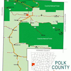
Rich Mountain is a small residential area that is part of a larger, 200-square-mile tract of land that lies in the Ouachita Mountains and spans the Arkansas-Oklahoma border. The name Rich Mountain applies to both the mountain and the community at its northern base. While few people reside in the community in the twenty-first century, the influence of the name can still be seen in area businesses.
In the early nineteenth century, the land that encompasses Rich Mountain changed hands several times. The United States first purchased the land from the French as part of the Louisiana Purchase in 1803. In 1820, the United States gave the Choctaw tribe the part of the Arkansas Territory that included Rich Mountain. The boundaries of the Choctaw land were altered in 1825 to reflect the boundary between Arkansas and Indian Territory (present-day Oklahoma) and again between 1831 and 1833.
The earliest white settlers came to Rich Mountain in the 1850s and 1860s. These settlers traveled to Rich Mountain for three main reasons: the rich soil, which was useful for growing vegetables; the spring water and mountain air, believed by settlers to be healing in nature; and people’s desire to live at higher elevations due to the prevalence of malaria and tuberculosis in lowlands of Louisiana and Texas and the river bottoms of Arkansas and the southeastern portion of Indian Territory. A store, blacksmith shop, and moonshiner’s still sprung up during this time.
In 1875, William A. J. Beauchamp brought a printing press to the mountain, where he later published the Mountain Signal, Polk County’s first newspaper. The first issue was published in 1877, and it ran for seven years, printing new editions only when sufficient news justified an issue.
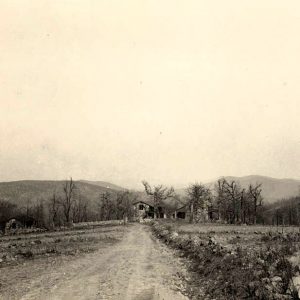
Though it had a post office as early as 1878, Rich Mountain officially became a town in 1890. The same year, A. Y. Hays and M. M. Triplett deeded one acre of land for use as a cemetery and combination church and school. About four years later, Arthur Stilwell—a Kansas City, Pittsburg and Gulf Railroad (KCP&G) executive—traveled to Europe to secure funding for a railroad that would extend to the deep-water ports of the southern United States. He found success in the Netherlands, where he secured three million dollars in funding to build the railroad. In 1897, Stilwell announced that a resort, Mount Mena, would be built at the mountain’s peak. Additionally, a road would be built from the KCP&G station to the new inn. The inn opened on June 22, 1898, under the name Wilhelmina Inn in honor of the queen of the Netherlands. By 1900, Stilwell lost control over construction of the railroad and KCP&G became Kansas City Southern (KCS). This led to the decline of the Rich Mountain community.
By 1905, the inn and hundreds of lots within the community had been disposed of through a lottery, with chances sold for thirty dollars each. Some 3,000 people attended the drawing, with E. A. Cotham of Monticello (Drew County) winning the inn. It closed permanently in 1910 and fell into disrepair.
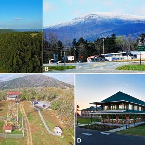
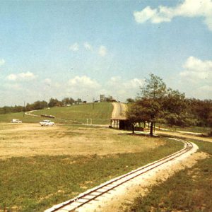
In April 1921, the U.S. Forest Service built trails to the mountain’s peak, which created scenic views accessible to the general public. The site became Queen Wilhelmina State Park in March 1957 through state legislation, and in 1959, work began on a second lodge, using the ruins of the first inn as its base. The inn formally reopened on June 22, 1963, sixty-five years after the grand opening of the first inn. This, combined with official naming of the Talimena Scenic Drive in 1966, brought tourists back to the Rich Mountain community.
The second lodge was destroyed by fire in November 1973, and a third inn was constructed in 1974–1975. The current lodge, park, and scenic byway bring visitors to the area each year. Tourists and locals alike enjoy camping, hiking, walking in the park, and eating at the Queen’s Restaurant.
While the earliest economic activity in the area revolved around the railroad, nearly all industry in the community in the twenty-first century pertains to tourism and the hospitality industry. Outside of Queen Wilhelmina State Park, the lodge, and the Queen’s Restaurant, the only other existing business in the Rich Mountain township is a fueling station.
The Rich Mountain area has several attractions, including Skyline Drive, which serves as the starting point for the Talimena National Scenic Byway; Queen Wilhelmina State Park; and the KCS Depot in downtown Mena, a frequent stop on the KCS Holiday Express route. Rich Mountain stands at 2,681 feet above sea level, making it the highest point in the Ouachita National Forest and the second-highest peak in the state of Arkansas.
For additional information:
Holleman, Bradley H. Mountain Memories: The History of Rich Mountain. Arkansas State Parks, n.d.
McWilliam, Aileen. Historical Sites: Talimena Scenic Drive. Mena, AR: United States Forest Service, 1974.
Vail, Roy. Mena and the Queen Wilhelmina Inn: A Brief History. Mena, AR: Desert Biological Publications, 1995.
Mysti L. Gates
University of Arkansas Rich Mountain


Comments
No comments on this entry yet.