


501-918-3025
calsfoundation@cals.org
calsfoundation@cals.org
| Latitude and Longitude | 35°25’36″N 091°50’13″W |
|---|---|
| Elevation: | 348 feet |
| Area: | 0.54 square miles (2020 Census) |
| Population: | 500 (2020 Census) |
| Incorporation Date: | April 8, 1911 |
Historical Population as per the U.S. Census:
|
1810 |
1820 |
1830 |
1840 |
1850 |
1860 |
1870 |
1880 |
1890 |
1900 |
|---|---|---|---|---|---|---|---|---|---|
|
– |
– |
– |
– |
– |
– |
– |
– |
– |
– |
|
1910 |
1920 |
1930 |
1940 |
1950 |
1960 |
1970 |
1980 |
1990 |
2000 |
|
– |
706 |
634 |
595 |
669 |
489 |
654 |
673 |
630 |
654 |
|
2010 |
2020 |
|
|
|
|
|
|
|
|
|
601 |
500 |
|
|
|
|
|
|
|
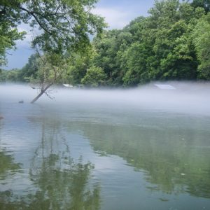
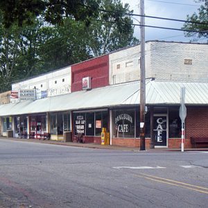
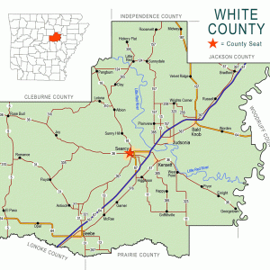
Pangburn is an incorporated second class city in extreme northwestern White County, located on Arkansas Highway 16 about halfway between Searcy (White County) and Heber Springs (Cleburne County). The city is located a quarter-mile south of the Little Red River, which made possible the arrival of the first white settlers in the 1850s, decades before any railroad was built through the isolated, hilly terrain. Pangburn once served boats on the Little Red back when the river was commercially navigable. It incorporated in 1911, shortly after the Missouri and North Arkansas Railroad (M&NA) built a line through the city.
At one time, Native Americans had inhabited the area, as the first white settlers to the area reportedly discovered the remnants of an Osage tribal village north of what would become Pangburn and even utilized some of their structures to shelter their animals. In the territorial and early days of Arkansas statehood, impassible and flood-prone terrain usually forced traders and immigrants to journey via river traffic. The King family, the first recorded white settlers, traveled by flatboat up the Little Red River via the White River and arrived in the area around 1817. The story goes that, along the river, the King family saw “a beautiful apple tree in full bloom and a [field] of wild maize” and decided to settle there. Another family named Judson later emigrated from Tennessee, lending their name to the community for a time. The settlement then named Judson established its first post office in 1856. During the Civil War, part of the old Military Road east of the city was used to ferry supplies to Confederate troops, but no recorded action during the war took place near Pangburn.
At that time, the city consisted of a community church and a few general stores, one of which was owned by Judson, who operated the first post office out of his store. The city was renamed Pangburn in 1880 for Dr. William David Pangburn, who emigrated from Schenectady, New York, with his family around 1860. In addition to his medical practice, Pangburn purchased a forty-acre farm and later purchased another eighty acres, on which the present city of Pangburn is located.
Further commercial development took place when the M&NA Railroad built its line through Pangburn in 1908. Also in the early 1900s, the Western Tie and Timber Company from Linn Creek, Missouri, moved to Pangburn and began cutting timber, utilizing the river to move the logs. As timber clearing commenced in earnest, newly cleared lands enabled the growth and ginning of cotton on a commercial scale. Extant records and the recollections of locals regarding the volume of cotton transported are wildly inconsistent, but it is clear that cotton farming expanded significantly once the M&NA rail line had been built. Saw logs, cross ties, and thousands of bales of cotton were transported via the railroad, and three cotton gins were in operation locally. Commercial prosperity later stagnated as the M&NA experienced a worker strike starting in 1921, coupled with the Great Depression later that decade. Operations on the M&NA line ceased altogether in 1946.
In the early 1960s, the Pangburn area saw the construction of a Titan II missile silo about five miles southeast of the city. The silo, designated Titan II Launch Complex 373-4, was part of the 308th Strategic Missile Wing (SMW) based out of Little Rock Air Force Base in Jacksonville (Pulaski County). Complex 373-4 near Pangburn was the first launch facility to be built in Arkansas and, in May 1963, was the first facility to be placed on strategic alert. On August 9, 1965, a fire broke out inside the silo during a maintenance project, killing fifty-three men. The fire was later determined to have been caused by the ignition of flammable hydraulic fluid inside a high-pressure line that was accidentally struck by a welding rod.
In the latter half of the twentieth century, Pangburn attained a reputation as a fishing destination, particularly for brown and rainbow trout. When the Greers Ferry Dam was completed in 1962, the Little Red River was no longer commercially navigable, but the cold water from the bottom of Greers Ferry Lake that was released into the Little Red enabled trout populations to thrive. Ever since the U.S. Fish and Wildlife Service has stocked trout in the Little Red below the dam, this stretch of river has been well known for its excellent fishing. Access to recreation on the river has also made the Pangburn area a desired destination for retirees seeking respite from more densely populated cities and urban areas. In the 2000s, oil and gas industries began accessing latent natural gas deposits in the Pangburn area, which is within the rich Fayetteville Shale; the industry had dwindled, however, by 2016. The population of Pangburn was 601 according to the 2010 census. The Pangburn School District includes an elementary, middle, and high school and serves approximately 700 students in the area.
For additional information:
Butler, Billie. “The Town of Pangburn and the Little Red River.” White County Heritage 1 (July 1963): 20.
Carr, Dennis Edward. “Pangburn, Arkansas.” White County Heritage 9 (January 1971): 11.
Johnson, Claude E. The Humorous History of White County, Arkansas. Searcy, AR: White County Historical Society, 1975.
White County Historical Society. http://www.whitecounty.us/ (accessed August 5, 2022).
Adam Miller
Searcy, Arkansas


I happened upon the Pangburn article after seeing the name and some related information. The article explained that Dr. Pangburn had moved from a farm in Schenectady, New York, with his medical practice. What really caught my attention was I believe I may have grown up in or around one of the Pangburn houses.
From the early 1980s I grew up in a large multi-family house with a barn and maybe 15 acres of land. This was on the corner of Pangburn and Duanesburg roads in Schenectady County, New York. I recall being in an agricultural family. My mother had explained to me that many of the roads in the area were named after the settling families and that may have been the old Pangburn farm.
I recall some very old dentist chairs stored in the barn, and in reading the article, there were many brow-raising points that had my interest. I understand your local history begins with Pangburn moving south, but I hope this was helpful since I enjoyed the article, as it seemed to continue the history once the property I grew up in changed hands.
The Pangburn road itself did have a few other farms along it. From what I remember there was another just on the opposite side of Interstate 88 approximately 1/4 mile north of where I grew up.
That was very interesting; I didn’t know any of that. I’ve been wanting to know the history of Pangburn.