calsfoundation@cals.org
Mountainburg (Crawford County)
| Latitude and Longitude: | 35º38’08″N 094º10’03″W |
| Elevation: | 751 feet |
| Area: | 1.47 square miles (2020 Census) |
| Population: | 528 (2020 Census) |
| Incorporation Date: | August 3, 1882 |
Historical Population as per the U.S. Census:
|
1810 |
1820 |
1830 |
1840 |
1850 |
1860 |
1870 |
1880 |
1890 |
1900 |
|
– |
– |
– |
– |
– |
– |
– |
– |
– |
– |
|
1910 |
1920 |
1930 |
1940 |
1950 |
1960 |
1970 |
1980 |
1990 |
2000 |
|
– |
– |
213 |
185 |
405 |
402 |
524 |
595 |
488 |
682 |
|
2010 |
2020 |
|
|
|
|
|
|
|
|
|
631 |
528 |
|
|
|
|
|
|
|
|
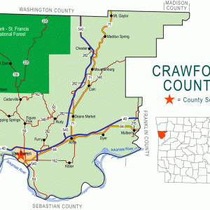
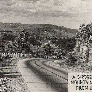
Mountainburg is located on U.S. Highway 71 near Lake Fort Smith State Park, on the Boston Plateau of the Ozark Mountains. Known to tourists for its scenic mountain views, Mountainburg has been a landmark for travelers throughout its history.
Between 1817 and 1828, the land around Mountainburg was included in territory assigned by the U.S. government to the Cherokee. After the Cherokee were removed to Indian Territory (now called Oklahoma), white settlers began to claim the land. One of the first landowners in what would become Mountainburg was George Dyer. Another was Samuel Caswell Vaught, a German-American veteran of the wars with various Native American tribes in the southern states and territories. Vaught was the father of seven sons, four of whom fought in the Civil War—three for the Confederate army and one for the Federal army. Local historians claim that half of the long-term residents of the Mountainburg area are descended from Vaught.
Mountainburg was a stop on the Butterfield Overland Mail Company route that was established through northwestern Arkansas in 1858. By that year, the community already had a grist mill, a sawmill, a store, and a hotel. It also had a primitive one-room school house. Most families lived in log cabins. A Masonic lodge was built in Mountainburg in 1874. In 1876, a post office was opened in Mountainburg at the same time that the post office was closed in a nearby settlement called the Narrows. Construction of the St. Louis–San Francisco Railway (commonly called the Frisco) through the community brought many travelers, which led to new businesses and a growing population. The city incorporated in 1882. By 1900, it included a barbershop, several stores, the Creekmore Hotel, and a telephone system, as well as the school, the post office, and the railroad depot.
The Masons built the Amrita Grotto Country Club between Alma (Crawford County) and Mountainburg in the mid-1920s; it later burned and most of the ruins were pushed over a cliff to keep people from being injured while exploring the site. A Presbyterian church was organized in 1927. The church began a mission school for children that also attracted adult students wanting to learn to read. During the 1930s, Fort Smith (Sebastian County) and Crawford County officials began to develop a source of drinking water, also planned to be a recreational area, in the Ozark National Forest near Mountainburg. Works Progress Administration (WPA) workers helped to create the lake and surrounding facilities. Lake Fort Smith became a state park in 1967. In 1942 (some sources say 1922), a steel bridge was built across the Frog Bayou (also known as Clear Creek) near Mountainburg. The bridge was used until 1994. It was added to the National Register of Historic Places in 1995.
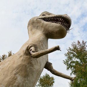
The construction of Interstate 540 (now Interstate 49) west of Mountainburg has reduced traffic through the city. School consolidation in the twentieth century closed rural school districts in Crawford County but enlarged the Mountainburg School District, which (as of 2013) serves nearly 700 students, kindergarten through high school. Mountainburg is home to five churches—Presbyterian, Assembly of God, Baptist, Lutheran, and Freewill Baptist—as well as two restaurants, a store, and a bank. Mountainburg is also noted for two dinosaur replicas built in the city park during the 1980s. Lake Fort Smith State Park was closed and relocated early in the twenty-first century; the new park opened in the summer of 2008. Woodcarver Ivan Denton and writer Skip Hays have both adopted Mountainburg as their hometown.
On April 13, 2018, an EF-2 tornado struck Mountainburg, injuring several people and damaging more than 150 structures.
For additional information:
Hopkins, Eula, and Wanda M. Gray. History of Crawford County, Arkansas. Van Buren, AR: Historical Preservation Association of Crawford County, Arkansas, 2001.
Mennenoeh, Paul. “Mountainburg, a Picturesque Community.” The Heritage 7 (October 1963): 37–38.
Vaught, Elsa. “A Sketch of the Vaught Cemetery.” Arkansas Historical Quarterly 14 (Winter 1955): 374–380.
Steven Teske
Butler Center for Arkansas Studies


Additional information regarding the Masonic Amrita Grotto Lodge can be found at this link from the Springfield, Missouri, library–including an image of the lodge. https://thelibrary.org/lochist/frisco/magazines/fem_1930_05/fem_1930_05.pdf