calsfoundation@cals.org
Horatio (Sevier County)
| Latitude and Longitude: | 33º56’18″N 094º21’26″W |
| Elevation: | 407 feet |
| Area: | 1.78 square miles (2020 Census) |
| Population: | 920 (2020 Census) |
| Incorporation Date: | October 11, 1898 |
Historical Population as per the U.S. Census:
|
1810 |
1820 |
1830 |
1840 |
1850 |
1860 |
1870 |
1880 |
1890 |
1900 |
|
– |
– |
– |
– |
– |
– |
– |
– |
– |
625 |
|
1910 |
1920 |
1930 |
1940 |
1950 |
1960 |
1970 |
1980 |
1990 |
2000 |
|
605 |
1,038 |
1,028 |
809 |
776 |
722 |
852 |
989 |
793 |
997 |
|
2010 |
2020 |
|
|
|
|
|
|
|
|
|
1,044 |
920 |
|
|
|
|
|
|
|
|
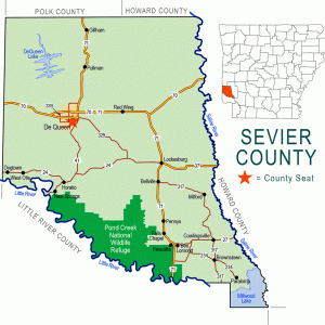
Horatio is a second-class city in Sevier County. Located on the Kansas City Southern Railway about six miles south of De Queen (Sevier County), Horatio lies near the Little River. The poultry industry and various manufacturing jobs—including James McCoy’s sawmill, established in 1892, and EZ Products Inc., manufacturer of cleaning chemicals, established in 1984—have shaped the character of the city in recent years, and its population is now more than one-third Hispanic, according to census records.
The Sevier County region has evidence of human habitation that stretches over the past 10,000 years. Hunting and fishing were the primary occupations of those who dwelt in the area or crossed through it. Settlers of European descent began to enter the river valleys of southwest Arkansas in the nineteenth century. Among the families that began farming in the vicinity of what is now Horatio before the Civil War were those of Henry Carter Pride, Isaac Newton Jackson, John Griffin, and Wesley Everett. The unincorporated community that developed on the road linking Paraclifta (Sevier County) to Ultima Thule (Sevier County) was known to local residents as Rock Hill. Pride was the sheriff of Sevier County during the Civil War. Griffin ran an inn and boarding house after the war, and Everett owned a store where the first school in the area also met.
When the Texarkana and Fort Smith Railroad began planning its route through western Arkansas, several families cheerfully granted right-of-way to the railroad. The new city—envisioned as growing alongside the railroad, just north of the bridge over the Little River—was surveyed on January 10, 1895, by William Worth Millwee on a portion of the Pride farm. Two land parcels were added to the original plat that year, and more land was acquired by the growing city in 1903 and in 1917. The name of the city was provided by Fred Hubbell, the general manager of the Texarkana and Fort Smith Railroad, to honor his father and also as an homage to his hero from Roman history, Horatius Cocles, who defended Rome from the army of Lars Porsena about 508 BC, fighting a key battle upon a bridge over the Tiber River. According to local historians, some conflict within the railroad company regarding the location and architecture of the bridge brought Horatius to Hubbell’s mind and led to the naming of the city.
A post office was established in 1895, and a two-room frame schoolhouse was built in 1898. The city was incorporated in the fall of 1898, although some paperwork was not formally completed until January 1900, when the city government was formed. By this time, the Texarkana and Fort Smith Railroad had been acquired by railroad magnate Arthur Stilwell and made part of the Kansas City Southern Railway. Four churches were organized—Baptist, Christian, Methodist, and Presbyterian—and a baseball team was created to compete with the teams of neighboring cities and towns. Stores and hotels were built, as well as an opera house that was also used for school plays and political rallies. The first newspaper printed in Horatio, the Herald, began publication in 1897.
In 1896, a race war between black and white railroad workers broke out in Polk County and near Horatio resulting in three deaths and eight casualties.
Additional construction and improvements in the early years of the twentieth century included electricity, first provided by S. R. Halliday, who generated electricity in the building that also housed a grist mill, until the Arkansas Light and Power Company in De Queen was granted the franchise in 1917. Sidewalks were built at city expense in 1913. A larger school building was completed in 1919, by which time the Bank of Horatio had also been established. During the 1920s, school consolidation gathered four smaller districts into the Central District, which was in turn consolidated into the Horatio school district in 1931. Eight more small districts also were consolidated into Horatio’s schools during the next two years. In addition to cotton and timber, southern Sevier County also supported a thriving fruit industry. Peach orchards were planted in the Horatio area, and strawberries also were cultivated in the county. The Great Depression devastated all these industries, and the Bank of Horatio was forced to close in 1935. The next year, the Bank of Gillham relocated to Horatio and opened as the Horatio State Bank.
During the second half of the twentieth century, the poultry industry became established in southern Sevier County, drawing many Hispanic workers and their families into the area. In 2010, 298 of Horatio’s 1,044 residents were Hispanic, and more than one-third of the students in its schools were of Hispanic origin.
In 2010, the Horatio Elementary School had 419 students, and the Horatio High School had 377 students. The city has three restaurants, two grocery stores, and six churches listed among its fifty-eight businesses. Horatio was the home of poet Bess Miller Moore (a.k.a. besmilr moore brigham) for many years, and the birthplace of state auditor F. Nolan Humphrey and Supreme Court of Arkansas justice Minor Millwee.
For additional information:
McCommas, Betty. The History of Sevier County and Her People. Dallas, TX: Taylor Publishing Company, 1980.
Steven Teske
CALS Encyclopedia of Arkansas


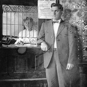
In the photo with this entry, my great-grandfather William Lovin Greer stands in the Horatio post office. He was the postmaster.
My father’s parents, John and Bettie Morgan, were residents of Horatio in the 1930-1950s. They lived in a house located where the post office is today.