501-918-3025
calsfoundation@cals.org
calsfoundation@cals.org
Latitude and Longitude: 35º45’22″N 089º55’41″W
Elevation: 246 feet
Area: 0.85 square miles (2020 Census)
Population: 942 (2020 Census)
Incorporation Date: June 3, 1897
Historical Population per the U.S. Census:
|
1810 |
1820 |
1830 |
1840 |
1850 |
1860 |
1870 |
1880 |
1890 |
1900 |
|---|---|---|---|---|---|---|---|---|---|
|
– |
– |
– |
– |
– |
– |
– |
– |
– |
943 |
|
1910 |
1920 |
1930 |
1940 |
1950 |
1960 |
1970 |
1980 |
1990 |
2000 |
|
677 |
1,179 |
1,074 |
1,258 |
1,302 |
1,236 |
1,566 |
1,739 |
1,338 |
1,317 |
|
2010 |
2020 | ||||||||
|
1,178 |
942 |
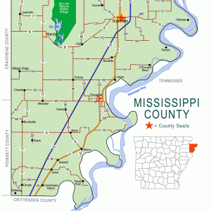
The city of Luxora is located in Mississippi County at the junction of U.S. Highway 61 and Arkansas State Highway 158, twelve miles south of Blytheville (Mississippi County) and five miles north of Osceola (Mississippi County). As one of the earliest settlements in the county, Luxora has been defined by the Mississippi River.
Originally known as Elmot Landing, the town was first located on the banks of a Mississippi River chute, drawing its name from its proximity to Elmot Bar. Due to its favorable venue as a river landing, Elmot began as a small settlement of businesses that catered to the river trade. One of its earliest settlers was Dempsey T. Waller, a dry-goods merchant who established a one-room store on the banks of the river in 1882. The Tiger Brothers General Store, established by Latvian immigrants—most likely Jewish—Nathan and Isidor Tager, was another enterprise that was well known throughout the region, earning Elmot the nickname of “Tiger-Town.”
As steamboats played a major role in the transportation of goods and passengers up and down the river, Elmot grew into a thriving village with its own post office (located in Waller’s storefront), hotels, dry goods, and other services that supplied the needs of travelers, riverboat captains, and local settlers. The Anchor, Collar, and Lee Line steamers provided Elmot with a steady stream of economic activity and bustling river life.
Although Elmot depended on the Mississippi River for its livelihood, the risk of flooding was a constant threat to its survival. After floodwaters repeatedly inundated the town, it became necessary to relocate behind the levee. Once a mosquito-infested swampland, these newly drained lands were initially part of a vast acreage amassed by Desecration Harrington through his purchase of land certificates authorized by the Swamp Land Act of 1850. After Harrington’s death, his lands were eventually divided among his heirs and later sold off in smaller, individual parcels to pay mounting debts and taxes. One of these parcels was purchased for $50 by Dempsey T. Waller. Subsequently, this tract of land became part of Elmot’s expanded boundary.
Upon the town’s incorporation in 1897, it was suggested by John B. Driver, the town’s first mayor, to rename the community in honor of Waller’s youngest daughter, Luxora, born in 1879. Waller’s profitable river trade allowed him to build one of the first family homes on Canal Street. “Miss Luxora,” the town’s namesake, lived in this home throughout her life until her death in 1959 and was a valuable source of information about the early history of the community.
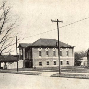
As the densely forested swamplands were cleared and agriculture increased, Luxora became a profitable hub for farming and the transport of timber and crops. Even as the steamboat era came to a close at the turn of the century, the newly arrived railroads and the explosion of the timber trade pumped new energy into Luxora’s economy. Sawmills, cotton gins, stave mills, and warehouses were constructed along the tracks to take advantage of the transportation system. Over the next two decades, the increased commercial activity brought further expansion to Luxora with the addition of schools, churches, grocery stores, banks, movie theaters, civic organizations, and a newspaper.
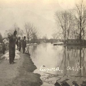
In spite of ongoing levee projects designed to protect the Delta towns and farmland from potential flooding, the historic floods of 1927 and 1937 caused extensive damage and economic hardship throughout the region. A collection of photographs taken in Luxora at the time of the 1927 disaster provides a glimpse of the flood’s toll on the town. As floodwaters spilled over the levee and engulfed the commercial and residential districts of Luxora, stranded travelers can be seen awaiting rescue on the balconies of the Arno Hotel, while citizens make their way through the submerged streets in rowboats.
The onset of World War II brought new challenges to the agricultural community in the form of critical manpower shortages. Relief was provided with German prisoner-of-war camps, established throughout eastern Arkansas to house soldiers and provide the needed labor to work the crops and machinery. One of these installations was located in Luxora at the site of a former barrel factory on Highway 61. Operating under the jurisdiction of Camp Joseph T. Robinson from 1944 to 1946, the camp was authorized to accommodate a capacity of 245 enlisted men. The majority of the captured soldiers were part of the German Afrika Korps and were used as contract laborers to chop, pick, and pull cotton. Leaders in the farming community agreed that the crop of 1945 would have been impossible to harvest without the assistance of the German captives.
Like many other small towns in the Arkansas Delta, Luxora has experienced a gradual decline over the course of several decades, becoming dependent on the surrounding larger communities of Osceola and Blytheville for goods and services. This downturn can be linked to floods, the mechanization of farming, and the decline of railroads—resulting in the migration of the labor force. To compound these events, the Main Street business district suffered a fire in 1945 that destroyed four brick buildings. The remaining businesses struggled to survive but slowly disappeared over time, leaving the shopping district with numerous boarded-up, abandoned structures that were ultimately demolished. Today, only a handful of businesses survive.
Due to consolidation, Luxora High School was closed in 1986. The junior high closed soon after. Students from both campuses now attend classes at Rivercrest in Wilson (Mississippi County). On February 14, 2012, a special election was held by the South Mississippi County School District seeking voter approval for a millage increase to build a new elementary school adjacent to the Rivercrest campus. In spite of local opposition, the millage increase was approved, resulting in the scheduled closure of Luxora Elementary School in 2014.
In order to fulfill community recreation needs, a nonprofit organization was established in 2005 by a group of concerned citizens. Located in the former high school gymnasium, the Charles Strong Recreation Center provides area youth with sports, summer camps, and other enrichment activities.
For additional information:
Biographical and Historical Memoirs of Northeast Arkansas. Chicago: Goodspeed Publishing Co., 1889.
Edrington, Mabel. History of Mississippi County. Ocala, FL: Ocala Start Banner, 1962.
Harrison, Robert W., and Walter M. Kollmorgen. “Land Reclamation in Arkansas under the Swamp Land Grant of 1850.” Arkansas Historical Quarterly 6 (Winter 1947): 369–418.
Pritchett, Merrill R., and William L. Shea. “The Afrika Korps in Arkansas, 1943–1946.” Arkansas Historical Quarterly 37 (Spring 1978): 3–22.
Tompkins, Frank H., comp. Riparian Lands of the Mississippi River: Past, Present, Perspective. Chicago: A. L. Swift & Co., 1901. Online at http://www.archive.org/details/riparianlandsofm00tomp (accessed June 29, 2022).
Whayne, Jeannie, and Willard B. Gatewood, eds. The Arkansas Delta: Land of Paradox. Fayetteville: University of Arkansas Press, 1993.
Toney Butler Schlesinger
Granite Bay, California


My dad was a truck driver for Coke or Pepsi around the time the POWs were there in Luxora. He delivered drinks to Rosa store. When I was four or five, I met a young boy a little older and we became friends. This country store had a tent for a movie theater. Just wondering if anyone else remembers it.
My father, Grant Harold Collar Sr., was the farm manager for R. C. Langston who owned a plantation at and around Rosa, AR, a few miles north of Luxora. He was half-German and had studied German at Arkansas State Teachers College and had a working knowledge of the language. He was one of the first to “employ” the German POWs to work on the Langston farm. He discovered quickly that a very small lunch was sent out from the camp–too small for people to do a lot of work. We had a company store at Rosa, and Dad would take a whole bologna, bread, crackers, etc., out to the field at lunchtime each day. He developed a relationship with some of the Germans that lasted for decades through letters. I am proud of my dad for treating them like men. They responded by never giving a minute’s trouble and working diligently.