501-918-3025
calsfoundation@cals.org
calsfoundation@cals.org
| Latitude and Longitude: | 36º13’45″N 091º45’52″W |
|---|---|
| Elevation: | 873 feet |
| Area: | 13.36 square miles (2020 Census) |
| Population: | 2,440 (2020 Census) |
| Incorporation Date: | October 2, 1969 |
Historical Population as per the U.S. Census:
|
1810 |
1820 |
1830 |
1840 |
1850 |
1860 |
1870 |
1880 |
1890 |
1900 |
|---|---|---|---|---|---|---|---|---|---|
|
– |
– |
– |
– |
– |
– |
– |
– |
– |
– |
|
1910 |
1920 |
1930 |
1940 |
1950 |
1960 |
1970 |
1980 |
1990 |
2000 |
|
– |
– |
– |
– |
– |
– |
321 |
1,909 |
2,239 |
2,278 |
|
2010 |
2020 |
|
|
|
|
|
|
|
|
|
2,184 |
2,440 |
|
|
|
|
|
|
|
|
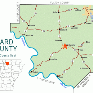
Horseshoe Bend is the only city in Arkansas that includes land from three counties within its city limits. The bulk of the retirement and resort community lies in Izard County—in fact, it is the largest city in Izard County, with a population of 2,184 as of the 2010 census—but parts of Horseshoe Bend extend into Sharp and Fulton counties as well.
The Strawberry River runs ninety miles through the forested hills of northern Arkansas. About half the river has been designated part of the Arkansas Natural and Scenic Rivers System. Prior to 1960, no single bend of the river was called “Horseshoe Bend.” The descriptive name was used to identify several parts of the winding stream. At the time of the Louisiana Purchase, northern Arkansas was claimed as hunting land by the Osage, whose villages were in southern Missouri. Even after the Osage were relocated farther west by a series of treaties culminating in 1825, they were only slowly replaced by settlers of European origin. Plans to control the Strawberry River with a dam, enhancing recreational opportunities as well as protecting farmland, were considered as early as 1938, but the proposed dam was delayed by World War II and later deemed unnecessary.
In the late 1950s, Bill and Dick Pratt sold 200 acres of land to a group of developers from Texas. The brothers—businessmen from Little Rock (Pulaski County) and Newport (Jackson County), respectively—had purchased abandoned land for a retirement community. The Texas developers began selling lots, but they then defaulted on their business loans, and the Pratts regained control of the community. Purchasing additional land, they continued selling lots, as well as creating streets and utilities for the new houses. Where the woods reportedly once hid a whiskey still, an airport was built. Creeks that flowed into the Strawberry River were dammed to create several lakes. Cedar Glade Lake failed to fill with water as was intended; engineers discovered that the water was emptying into a previously unknown cave. They spent more than $100,000 plugging holes in the bottom of the lakebed. As of 2011, the lakebed remains dry. A feature called Gobbler’s Knob, frequented by local hunters, was converted into the Turkey Mountain Golf Course. Construction began in 1961, and the first nine holes were open to the public in 1963; the remaining nine holes were finished in 1971.
The Pratts employed a sales team that at one time had 100 employees. In all, they created fifty-six subdivisions on 14,000 acres, and by 1974, they had sold 12,000 lots. Many of the houses were prefabricated. More than half of the new residents were from Illinois (which accounted for one quarter of the residents), Missouri, Iowa, Indiana, and Wisconsin. The city was incorporated in 1969, creating a city government and a police force, as well as guaranteeing oversight of the city’s utilities. Various new churches were formed, including Lutheran, Episcopal, and Roman Catholic; each was the first of its denomination in Izard County.
Albert Gannaway, a film and television producer best known for his work with the Grand Ole Opry, helped to create a small theme park in Horseshoe Bend called Ozarkland. The frontier homestead at the center of the project, built in 1969, was meant to be used as a stage for a television program called Ozarkland Jamboree. The musicians for the program and park came from West Virginia and Tennessee. Both the program and the park failed. Gene Williams of West Memphis (Crittenden County) acquired the facilities in the early 1970s and tried to create an amusement park he called Frontierland, but this effort also failed.
In spite of these failures, the development of Horseshoe Bend provided new jobs for many residents of the area. Retired farmers and business professionals opened shops and restaurants, and roughly half the sales staff of the development hailed from Arkansas. Construction jobs also employed workers whose previous income from farming had been considerably less. Not only did Horseshoe Bend bring the first golf course and first public swimming pool into the region, but it also introduced the first Kiwanis club and the first legal drinking establishments.
In 1974, the Pratts decided to sell their business to Gulf South Advisors, Ltd., a consortium of bankers and other investment specialists. The Pratts were not aware that Gulf South was already in financial jeopardy; some local historians have suggested that the company intended to use the assets of Horseshoe Development Company to cover their other losses, and they estimate that $67 million meant for the upkeep and further development of the city was lost to Gulf South. Their lengthy bankruptcy hearings led to frequent threats to sell off the assets of Horseshoe Bend, but the fact that the city had already incorporated prevented that action from occurring. Instead, city leaders created a new agency, the Municipal Recreation Improvement District, to oversee city parks, including the golf course and the lakes. Former salespeople from the development company became real estate agents in Horseshoe Bend. Working together, city leaders and the agents were able to rescue the city from the threat of dissolution under bankruptcy laws.
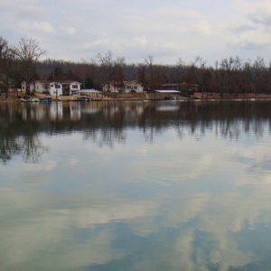
Horseshoe Bend continues to exist as a retirement community and resort. It has two golf courses and several lakes featuring fishing, boating, and other recreational activities. The largest lake, Crown Lake, covers 640 acres. The city has eight churches (Assembly of God, Baptist, Episcopal, Lutheran, Nazarene, Presbyterian, Roman Catholic, and United Methodist) as well as a number of restaurants, stores, and other businesses. Horseshoe Bend lies within the Izard County Consolidated School District, which was created in 1985 with the consolidation of Oxford (Izard County) and Violet Hill (Izard County) schools.
For additional information:
Blevins, Brooks. Hill Folks: A History of Arkansas Ozarkers & Their Image. Chapel Hill: University of North Carolina Press, 2002.
City of Horseshoe Bend. https://www.horseshoebend.org/ (accessed June 4, 2022).
Garner, Lynn, and Susan Varno. “History of Horseshoe Bend, a Planned Community.” Izard County Historian 30 (October 2005): 10–12.
Miller, John M. “Memories of Horseshoe Bend.” Izard County Historian 30 (October 2005): 13–16.
Steven Teske
Butler Center for Arkansas Studies


Comments
No comments on this entry yet.