
501-918-3025
calsfoundation@cals.org
calsfoundation@cals.org
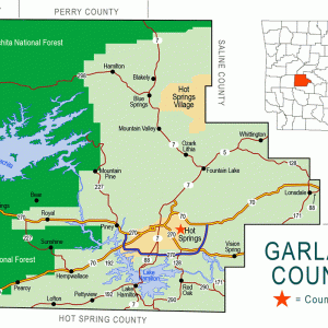
Crystal Springs (Garland County) is an unincorporated community located south of Lake Ouachita in the Ouachita National Forest. The community is about five miles west of Royal (Garland County) and seventeen miles west of Hot Springs (Garland County). The community is less than two miles south of Crystal Springs Campground on the shore of the lake.
The Crystal Springs area was part of Montgomery County during its earliest settlement. On February 23, 1917, the easternmost portion of Montgomery County, including Crystal Township where Crystal Springs is located, was transferred to Garland County.
Settlement of the area did not begin until after the end of the Civil War. Early settlers in the area include Francis Springer, who obtained 160 acres from the Federal Land Patent office in Camden (Ouachita County) in 1882. Springer also received a pension at the same time for his service in the Union army in a Tennessee unit during the Civil War. Joseph Tucker acquired 120 acres of land in the area in 1888, and Hiram Smith obtained 160 acres divided among three plots in 1889.
The Crystal Springs Cemetery received its first burials in the 1880s. The earliest marked grave belongs to Louis Tucker, who died in 1889 at the age of thirty. The Crystal Springs Post Office opened in 1880 and closed in 1964. The community is served in the twenty-first century by the Royal Post Office. A school operated in the community in the late nineteenth and early twentieth centuries, although details are scarce. First appearing on a list of rural districts in the county in 1929, the district eventually consolidated with the Lake Hamilton School District.
Crystal Springs and other nearby communities saw an influx of visitors in the 1880s as reports spread of possible gold and silver deposits in the nearby hills. The rumors proved to be untrue but did spur growth and economic investment in the area. The community of Bear (Garland County), located about three miles to the northeast of Crystal Springs, saw an immense influx of speculators and prospective miners.
The rumors of precious minerals led to the growth of the community, with an early map of the area detailing specific plans for expansion. Numerous streets were laid out, based on two east-west routes. The current route of U.S. Highway 270 connected Crystal Springs with Hot Springs, while another street named Crystal Avenue, located one block north, served as a commercial center of the community. These projects did not come to fruition, however. The Hot Springs, Bear Mountain and Crystal Springs Railroad incorporated in 1886 to serve the area and transport any minerals to market, but it never laid any track. One business that did operate for a time in the area was a smelter constructed by Elliott Moffet, a mine owner from Missouri. Open from 1886 to 1888, the smelter was located just north of the community.
The Civilian Conservation Corps Company 741 operated in the area to complete several projects during the Great Depression. Camp Clearfork, a recreational facility, was constructed by the company southwest of Crystal Springs. The complex includes cabins, a fieldstone dam on Walnut Creek, and a meeting hall, among other structures. The complex was added to the National Register of Historic Places on October 21, 1993, as the Camp Clearfork Historic District.
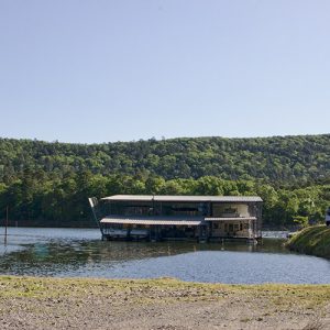
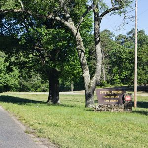
The geography and economy of the area changed in 1955 with the completion of Blakely Mountain Dam the Ouachita River. The dam created Lake Ouachita, located to the north of Crystal Springs, and attracts visitors to the community thanks the multiple outdoor recreational opportunities the lake provides. The community is also surrounded by the Ouachita National Forest.
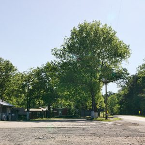
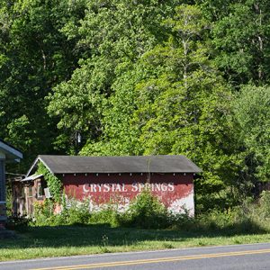
The community consists of several homes and businesses. These include a motel, church and restaurant along with several liquor stores. Many of these businesses are focused on serving visitors to Lake Ouachita. It serves as a bedroom community for Hot Springs, with many residents commuting there for jobs.
For additional information:
Anthony, Isabel. Garland County, Arkansas: Our History and Heritage. Hot Springs, AR: Garland County Historical Society, 2009.
———. “The Ouachita National Forest: 75 Years Younger than Hot Springs National Park.” The Record 48 (2007): 58–64.
Robbins, Elizabeth. “Garland County Rural Schools.” The Record 48 (2007): 65–96.
Sherman, Leonard. “E. R. Moffet: The Joplin Lead King.” The Record 28 (1987): 41–58.
David Sesser
Henderson State University


Comments
No comments on this entry yet.