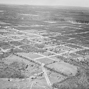
 Bull Shoals Aerial View
 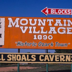 Bull Shoals Attractions
 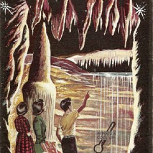 Bull Shoals Caverns Brochure
 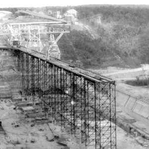 Bull Shoals Dam
 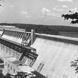 Bull Shoals Dam
 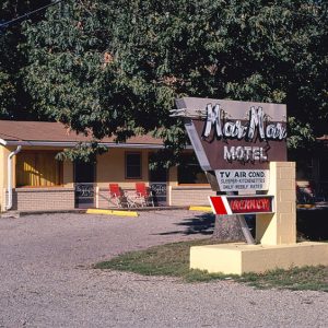 Mar Mar Motel
 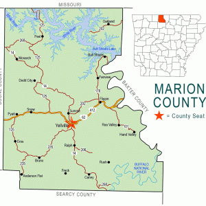 Marion County Map
 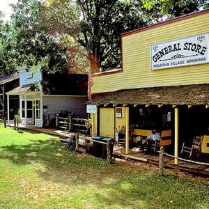 Mountain Village 1890
501-918-3025
calsfoundation@cals.org
calsfoundation@cals.org
| Latitude and Longitude: | 36º23’02″N 092º34’54″W |
| Elevation: | 787 feet |
| Area: | 4.90 square miles (2020 Census) |
| Population: | 1,952 (2020 Census) |
| Incorporation Date: | November 13, 1953 |
Historical Population as per the U.S. Census:
|
1810 |
1820 |
1830 |
1840 |
1850 |
1860 |
1870 |
1880 |
1890 |
1900 |
|
– |
– |
– |
– |
– |
– |
– |
– |
– |
– |
|
1910 |
1920 |
1930 |
1940 |
1950 |
1960 |
1970 |
1980 |
1990 |
2000 |
|
– |
– |
– |
– |
– |
268 |
430 |
1,312 |
1,534 |
2,000 |
|
2010 |
2020 |
|
|
|
|
|
|
|
|
|
1,950 |
1,952 |
|
|
|
|
|
|
|
Bull Shoals is located in Marion County about ten miles south of the Missouri state line. The origin of the town of Bull Shoals is related to the building of Bull Shoals Dam and the formation of Bull Shoals Lake. Bordered on three sides by Bull Shoals Lake, modern-day Bull Shoals is primarily a vacation and retirement community.
The town was the creation of Charles S. Woods Sr. A real estate developer, Woods had founded communities in Texas and Georgia. Bull Shoals was to be his fifteenth and final development. With the planned construction of Bull Shoals Dam and the forming of a nearby lake, Woods saw great potential for the area. With the backing of local investors, Woods formed the Ozarks White River Company and bought more than 1,000 acres of land from seventeen farmers in the Newton Flat area. Woods’s son, Charles Jr., joined his father and helped him survey and subdivide the land into 2,076 lots. Together, they cleared the land and drew the town’s original street plan on the back of a brown paper bag. The plan provided for over twenty miles of streets, including three thoroughfares over 100 feet wide: Central Boulevard, East Broadway, and West Broadway (now C. S. Woods Boulevard). On August 14, 1946, a plat was filed in the Marion County Courthouse for the new town of Bull Shoals, the first official document of the town. This was about a year before the groundbreaking ceremonies of Bull Shoals Dam.
Woods built a three-story observation platform in the center of the proposed town site. A clever sales device, the observation platform served not only as the headquarters of the real estate company but also gave potential buyers a grand view of all the lots. Woods’s advertising slogan was “A New Town Which Has a Great Future.” To beautify the area and attract buyers, Woods planted over 10,000 tulips and daffodils. He encouraged residents to do the same, believing the flowers would make the town a tourist attraction. Even today, descendants of the original bulbs can be found scattered throughout the town. By early 1948, over twenty percent of the lots had been sold even without paved streets, electricity, or a sewer system, and even before the dam or lake had been completed.
The original residents of the area were the workers, engineers, and supervisors of the dam. This area on the south edge of town is still referred to as “Super City.” Due to the lobbying efforts of Woods, a road (Highway 178) was built across the dam connecting Bull Shoals with Amos, now Lakeview (Baxter County). Bull Shoals Dam was dedicated on July 2, 1952, with President Harry Truman delivering the keynote address. The town at the time numbered a little over 100 residents, but more than 6,000 people attended the event.
Many businesses that define Bull Shoals had their origin in this early era. Everett and Bobbie Crow established the Crow-Barnes Resort (the present Bel’Arco Resort) in 1952, the first successful resort built in the town. Telephone service was brought to Bull Shoals by Raymond and Mildred Sanders in 1952. Their business eventually became the Northern Arkansas Telephone Company (NATCO). Roy Danuser established a number of tourist attractions that became closely associated with Bull Shoals, including Mountain Village 1890, Bull Shoals Caverns, and the Top O’ the Ozarks Tower. The tower, atop Bull Mountain, was made from old offshore drilling platforms and offers visitors a spectacular view of the region.
Bull Shoals was officially incorporated as a town on November 13, 1953, giving the town a mayoral form of government. Despite the ambitions of its founder, Bull Shoals remained a small community, not gaining status as a city of the second class until April 1972, when its population finally surpassed 500 residents. To achieve this status, the town annexed 800 acres of subdivisions next to the town.
In the 1960s and 1970s, Bull Shoals became not only an area for tourists and outdoorsmen but also a retirement destination. Many of the retirees migrated from northern areas, prompting locals to refer to Bull Shoals as “Little Chicago.” As of the 2010 census, Bull Shoals has a population of 1,950.
On land donated by the Woods family, a community center was established in 1951. Known as The Meeting Place, the center was built by the Chamber of Commerce. It was the first and one of the largest community projects of Bull Shoals and became the center of social life in the city. The community center was renamed the C. S. Woods Family Center in July 2010 in honor of the town’s founder.
For additional information:
“Bull Shoals Honors Founder Marguerite Woods.” Baxter Bulletin. July 22, 2010.
Robert Edward Harper. The History of Bull Shoals: The Best Little Town by a Dam Site. Bull Shoals, AR: Enterprise Printing, 2000.
Clement Mulloy
Arkansas State University–Mountain Home


Looking for the street my grandparents built their home on. Very steep, dead-ended at the water. They were neighbors with the former mayor named Les. His wife’s name was Sabina.