 Fayetteville Shale
 Karst Topography
 White Springs, Skirmish at
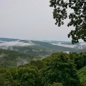 Boston Mountains
 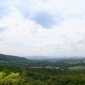 Boston Mountains
 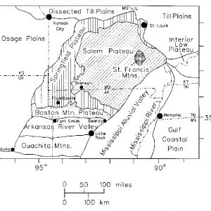 Ozark Plateau Map
501-918-3025
calsfoundation@cals.org
calsfoundation@cals.org
The Boston Mountains in north-central Arkansas are the southern portion of the Ozark Plateau geologic area. The Ozark Mountains extend across northern Arkansas and southern Missouri; this dome of rocks has been a relatively high area for the past 1.5 billion years. The most recent uplift of the Ozarks, including the Boston Mountains, occurred about 300 million years ago, and the mountains have been weathering and eroding since that time. This highland has the greatest relief (difference in the elevation from the valley bottoms to the mountain tops) of any formation between the Appalachian Mountains and the Rocky Mountains. The Boston Mountains portion of the Ozarks extends north of the Arkansas River Valley as a rectangle twenty to thirty-five miles wide and 200 miles long.
The rocks in the Boston Mountains are nearly all sandstone and shale that were deposited during the Pennsylvanian era, approximately 323 to 290 million years ago. The sandstone was deposited in two environments. The older sand beds were deposited by streams that flowed across a continent to an ancient ocean south of what is now the Boston Mountains. The younger sand beds were deposited at sea level in delta channels as water inundated the land. Between the sandstone layers are thick shale. The older shale beds were deposited on the floodplains beyond the stream channels. The younger shale beds were deposited in swampy areas between the delta channels and in the marine environment beyond the deltas.
This ancient coastline was permanently lifted high above sea level approximately 300 million years ago during the collision of the North American and South American continents. The brunt of the collision and resultant folding and faulting of the rocks is south of the Boston Mountain area, so there is minimal folding and faulting of rocks in the Boston Mountains. However, this uplift has allowed streams to erode deeply into these flat-lying rocks.
Sandstone, more resistant to erosion than shale, forms the mountaintops, cliffs of exposed rock, and steep slopes of the mountain sides. The shale forms tree-covered, relatively low-angled slopes. Because the rocks are horizontal and the sandstone and shale have varying resistance to erosion, the mountaintops are flat plateaus underlain by a resistant sandstone beds. The ledges or cliffs of sandstone beds with intervening relatively lower-angled slopes of shale encircle the mountain sides at nearly the same level.
This rugged topography has determined the land use of the Boston Mountains. Slopes remain forested and have been used for timber on a limited basis. Small pastures can be found on the mountain crests and valley bottoms. Travel across the mountains was difficult, and before the advent of automobiles and highways, it was easier to travel from Little Rock (Pulaski County) to northwestern Arkansas via St. Louis, Missouri, than to cross the Boston Mountains. The name of the mountains is perhaps a corruption of a French phrase for “rough road,” though other sources have noted that “a Boston” was slang in the American West for any difficult task. The mountains are still sparsely populated, and much of the area is part of the Ozark National Forest. Devil’s Den State Park and Lake Fort Smith State Park are located in the Boston Mountains.
For additional information:
Guccione, Margaret J. The Geologic History of Arkansas through Time and Space. Fayetteville: Arkansas and Regional Studies Center, 1993.
Guccione, Margaret J., producer. Arkansas through Time and Space. VHS. Fayetteville: University of Arkansas School of Continuing Education and Academic Outreach, 1991.
Maxfield, Ollie Orland. “Geography of the Boston Mountains.” PhD thesis, Ohio State University, 1963.
Margaret J. Guccione
University of Arkansas, Fayetteville


Comments
No comments on this entry yet.