 Lion
Lion
Entry Type: Thing - Starting with L
Lion
Lion Oil Company
Lion Oil is an El Dorado (Union County) corporation that refines and produces oil, gasoline, and other oil-based products. Its products include not only fuels and asphalt but industrial solvents and oil-based roofing products. Lion is a major employer in southern Arkansas, with more than 500 employees. When the oil boom began in southern Arkansas in 1920, Colonel Thomas Harry Barton, a Texas native, came to El Dorado and began investing in the emerging industry, organizing the El Dorado Natural Gas Co. In 1922, he took over a small refinery in El Dorado that became the Lion Oil and Refining Co. Initially, the refinery produced 2,000 barrels per day and employed twenty-five people. Reportedly, Barton decided to call the company …
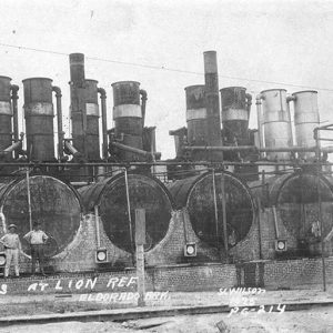 Lion Oil Stills
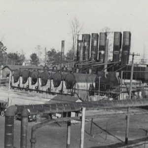 Lion Oil Stills
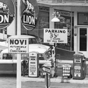 Lion Service Station
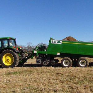 Litter Applicator
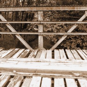
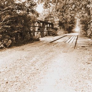
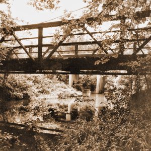
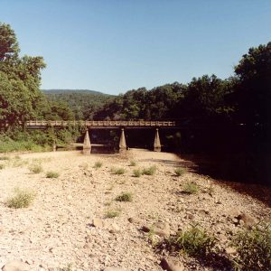 Little Buffalo River Bridge
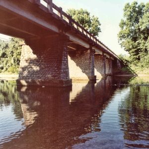 Little Buffalo River Bridge
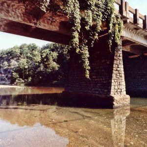 Little Buffalo River Bridge
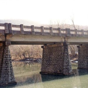 Little Buffalo River Bridge
Little Buffalo River Bridge
The Little Buffalo River Bridge is a concrete T-beam bridge located on Arkansas Highway 327 at its crossing of the Little Buffalo River about 1.5 miles northwest of Parthenon (Newton County). It was constructed in 1939 by the Works Progress Administration (WPA), a Depression-era public relief agency. The first white settler in the area where the Little Buffalo River Bridge is located was John Belah, who moved there in the 1830s. A road through the area connecting Jasper (Newton County) to Clarksville (Johnson County) was in place by 1844, and the village of Mount Parthenon (now Parthenon) was established seven years later. During the Great Depression, Newton County officials decided to take advantage of President Franklin D. Roosevelt’s New Deal …
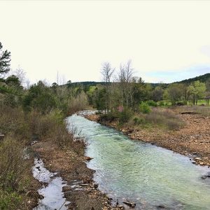 Little Cedar Creek
Little Girl from Little Rock [Song]
The song “Little Girl from Little Rock” is a featured number from a 1949 Broadway musical as well as a hit movie from 1953, both titled Gentlemen Prefer Blondes. With lyrics by Leo Robin and music by Jule Styne, the catchy song, with its slightly naughty lyrical content, was an “audience grabber.” As the opening number for both the Broadway production and the movie, it set the tone for both. Gentlemen Prefer Blondes was based on a bestselling comic novel written by Anita Loos. The book caused a sensation when it was published in 1925 and was soon adapted as a non-musical Broadway play in 1926 and a silent film in 1928. The book and the play centered on a …
Little Missouri River Bridge
aka: Nachitoch Bluff Bridge
The Little Missouri River Bridge, also known as the Nachitoch Bluff Bridge, is a through-truss bridge located north of the Interstate 30 crossing of the Little Missouri River, connecting Clark and Nevada counties. Beirne (Clark County) and Gurdon (Clark County) are the two closest communities to the bridge. The bridge was added to the National Register of Historic Places on April 9, 1990, and is depicted on a mural in Prescott (Nevada County) at the intersection of Main and First streets. It closed to traffic in the mid-1990s. Details about the construction of the bridge are scarce. Documentation suggests that it was constructed in 1908 by the Morava Construction Company. The main span of the bridge measures 185 feet and was …
 Little Missouri River Bridge
 Little Missouri River Bridge
 Little Missouri River Bridge
Little Red River
The Little Red River runs through north-central Arkansas, arising from several different forks in the Ozark Mountains. Major towns situated along the course of the river are Clinton (Van Buren County), Fairfield Bay (Van Buren County), Heber Springs (Cleburne County), and Searcy (White County), though the river also flows north of the old settlement of Georgetown (White County), where it empties into the White River. The Little Red River is dammed just east of Heber Springs, creating the reservoir of Greers Ferry Lake, which is a major regional tourist destination. The Little Red River passes through three different natural divisions of Arkansas: the Ozark Mountains, the Arkansas River Valley, and the Mississippi Alluvial Plain (the Delta). The forks of the …
Little River (Southwestern Arkansas)
The Little River rises in the Ouachita Mountains of southeastern Oklahoma, from which point it cuts west and then south before turning in a southeasterly direction and eventually entering Arkansas between Sevier and Little River counties. The river flows through Arkansas for ninety-two of its total 220 miles before emptying into the Red River near Fulton (Hempstead County). The Little River—not to be confused with a waterway of the same name in northeastern Arkansas—is impounded at Millwood Dam; the resulting reservoir, Millwood Lake, spreads across the corners of four southwestern Arkansas counties. One of its tributaries, the Mountain Fork of the Little River, is sometimes called the Mountain Fork River. The Little River has been the site of human habitation …
Little River County Courthouse
The Little River County Courthouse is located on Main Street in the heart of Ashdown (Little River County). The Arkansas Historic Preservation Program recognizes the two-story building as architecturally and historically significant as one of the most impressive county courthouses in Arkansas and as the most prominent structure in Little River County. It was added to the National Register of Historic Places on September 26, 1976. After voters moved Little River’s county seat from Rocky Comfort (Little River County) to Ashdown in 1906, the administration of Judge J. B. Arnett oversaw the construction of a new courthouse that began the following year. The county hired architect Sidney Stewart to design the building with the mission to solidify Ashdown’s claim as …
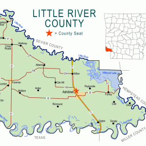 Little River County Map
 Little Rock
 "Little Rock," Performed by Collin Raye
 The Little Rock
Little Rock [Geological Formation]
aka: Point of Rocks
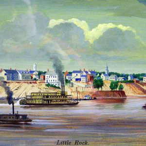
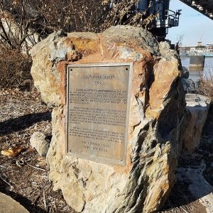
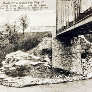
The Little Rock is the rock outcropping on the Arkansas River used as a navigation point during the early exploration of what would become the state of Arkansas. The town of Little Rock (Pulaski County) was established near this point. Sometimes called the Point of Rocks, it is the first rock on the Arkansas River as one ascends from the Mississippi. This is where the foothills of the Ouachita Mountains first touch the river, creating a natural plateau above the floodplain. The rock is sandstone deposited originally in a deep marine environment 320–300 million years ago, a part of what geologists call the Jackfork Formation. Jean-Baptiste Bénard de La Harpe, one of the earliest European explorers in the region, observed …
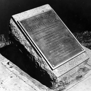 "Little Rock" Plaque
 Little Rock [Geological Formation]
Little Rock and Fort Smith Railroad
The Little Rock (Pulaski County) to Fort Smith (Sebastian County) railroad span was organized in November 1853 as the Little Rock and Fort Smith Branch of the Cairo and Fulton Railroad Company. In 1859, while it was still a company only on paper, the Arkansas General Assembly passed a proposed act allowing the Little Rock and Fort Smith Branch to merge with the Memphis and Little Rock Railroad, forming the Central Pacific Railroad. This merger never happened, but it clearly shows the manipulation of railroad markets in Arkansas. The start of the Civil War in 1861 postponed plans for the proposed Little Rock and Fort Smith Branch. Following the war, in 1866, Congress gave the State of Arkansas ten alternating …
 Little Rock Bicentennial Emblem
Little Rock Brewing & Ice Company
The Little Rock Brewing & Ice Company opened in August 1898 to much local fanfare. At the time, it was the only brewery in Arkansas. Founders John Doyle of Richmond, Virginia, and Philip Hildenberger of Philadelphia, Pennsylvania, had both been brewers in their hometowns. They successfully petitioned the City of Little Rock (Pulaski County) for a donation of $2,500 to help remodel the vacant Quapaw Cotton Mills property into a brewery and ice plant. By 1898, the buildings had been vacant for several years. They were ideal, however, for use by a brewery interested in using a gravity-fed brewing process. Importantly, the Quapaw Mills plant was only a couple of blocks from the Arkansas River and a railroad depot, the …
Little Rock City Hall
Little Rock City Hall is located on the northwestern corner of West Markham and Broadway in Little Rock (Pulaski County). Designed by noted architect Charles L. Thompson, it has been the seat of government for the state’s largest municipality since 1908. Interestingly, the Arkansas Gazette heavily opposed the building’s construction, even suing the city to stop it. The old Little Rock City Hall, constructed in 1867, was located at 120–122 Markham Street, the current location of the Statehouse Convention Center. Twenty years after its construction, the old city hall was in ruins, and calls for a new city hall were voiced. Arkansas Gazette editors wrote at the time, “It is to be noticed too, that our worthy council have not …
 Little Rock College Seal
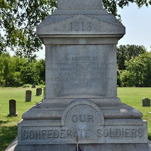
Little Rock Confederate Memorial
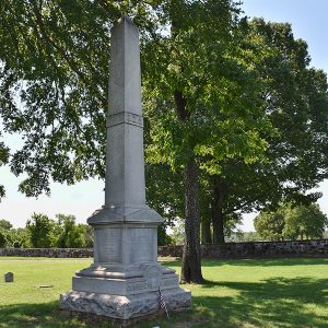
The Little Rock Confederate Memorial at Oakland-Fraternal Cemetery is a memorial shaft erected in 1914 on the burial site of 900 Confederate soldiers who died of disease while stationed in Little Rock (Pulaski County). Five months after the dedication of the Monument to Confederate Women at the Arkansas State Capitol, the Memorial Chapter of the United Daughters of the Confederacy (UDC) announced plans to mark the burial site of hundreds of Confederate soldiers adjacent to the Little Rock National Cemetery. The Arkansas Gazette reported on October 26, 1913, that the UDC chapter “is erecting a monument…in the southeast portion of Oakland cemetery….A stone coping encloses the plot of ground, where are buried 900 soldiers, most of whom died in St. …
 Little Rock Confederate Memorial at Oakland-Fraternal Cemetery
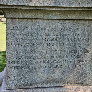 Little Rock Confederate Memorial Inscription
 Little Rock Confederate Memorial Detail
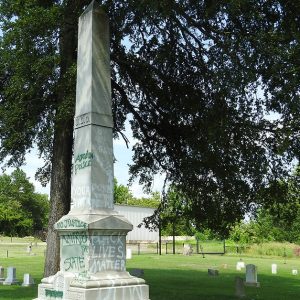 Little Rock Confederate Memorial Vandalism
Little Rock Debates on Evolution (1966)
The “Great Evolution Debate,” as it was billed, was held in Little Rock (Pulaski County) on June 28–29, 1966, following a decision by Judge Murray O. Reed on May 27, 1966, which declared that Arkansas’s 1928 law banning the teaching of evolution in Arkansas’s public schools was unconstitutional. A case challenging the right of a state to outlaw the teaching of evolution in public schools had been filed in the Pulaski County Chancery Court, with Little Rock Central High School biology teacher Susan Epperson as the point person. The case was heard in April 1966, leading to the decision by Judge Reed in May. Professor James D. Bales of Harding College (now Harding University) in Searcy (White County) led the …
Little Rock Fire Station No. 9
Little Rock Fire Station No. 9 is a two-story frame building with a brick veneer located at 2023 East Sixth Street in the Garlands Addition of Little Rock (Pulaski County). The fire station was designed by Little Rock architect H. Ray Burks and constructed in 1930 by the C. L. Hardin Construction Company of Little Rock. It was listed on the National Register on September 14, 2020. The Little Rock Fire Station No. 9 is characterized as a blend of Tudor Revival and Colonial Revival architectural elements, with a painted brick exterior, large brick chimneys, and both a steeply pitched gable roof and a gambrel roof with shed dormers, covered in asphalt shingles. The fire station is rectangular, with a …
Little Rock Free Press
aka: Arkansas Free Press
The Little Rock Free Press was an alternative newspaper based in Little Rock (Pulaski County). It began publication on April 20, 1993, and twelve years later, the Freep, as it was commonly called, became the Arkansas Free Press. The Little Rock Free Press covered everything from daily news to controversial topics such as prostitution, homosexuality, night life, drug culture, and Little Rock’s independent music scene. Often incurring the wrath of religious groups and politicians, the Freep was said by its editor to be “provocative Arkansas history with a twist.” In 1993, Little Rock’s previous alternative newspaper, Spectrum Weekly, ceased publication. It had been printed in Russellville (Pope County) but faced opposition from the printer and others after it began running …
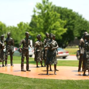 Little Rock Nine Monument
Little Rock Picric Acid Plant
Arkansans supported the American effort in World War I in many ways. Some served in the armed forces, while others worked to grow and conserve food and make clothing and bandages for the troops. Many worked in a number of war industries, including a munitions plant built outside of Little Rock (Pulaski County) in 1918, tasked with manufacturing a high explosive—a rapid and destructive chemical explosive—known as picric acid. Picric acid (trinitrophenol) is made of phenol and several acid compounds that, when combined under proper conditions, form a honey-like substance that can be loaded into artillery shells. It is stable enough to survive the shock of being fired from a cannon, but, when detonated by a fuse, is very destructive. …
Little Rock Port Authority
aka: Port of Little Rock
The Port of Little Rock, part of the McClellan-Kerr Arkansas River Navigation System, is operated by the Little Rock Port Authority (LRPA). The LRPA oversees the port, which provides intermodal transportation services to connect U.S. markets to the deep-water ports of the Gulf of Mexico. The port encompasses an industrial park located along the banks of the Arkansas River, approximately seven miles from downtown Little Rock (Pulaski County); the 2,600-acre industrial park has more than forty businesses. The Port of Little Rock operates two river terminals (a river port and a slackwater harbor) and a short-line railroad, as well as Foreign Trade Zone 14. (Foreign-trade zones are designated locations in the United States in which companies are able to delay …
Little Rock Railway & Electric Company (LRREC)
The Little Rock Railway & Electric Company (LRREC) played a key role in the electrification, modernization, and continued operation of the intra-urban streetcar transportation system that served the citizens of Little Rock (Pulaski County) in the late nineteenth and early twentieth centuries. Prior to electrification, the intra-urban streetcar system in Little Rock consisted of animal-drawn conveyances along the first rail lines built in 1877 by the Citizens’ Street Railway Company by businessmen from Little Rock and Hot Springs (Garland County). Over the next decade, technological developments, including the electric lamp (streetlight), more efficient power generation/distribution, and trolley pole systems allowed animal-drawn streetcars to be gradually replaced with electric streetcars. Early on, several streetcar companies—such as Capital City Street Railway Company, …
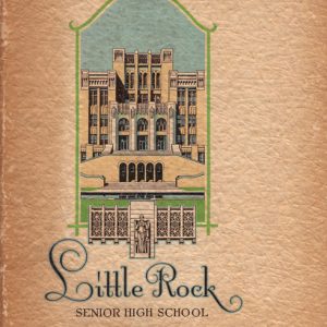 Little Rock Senior High Yearbook
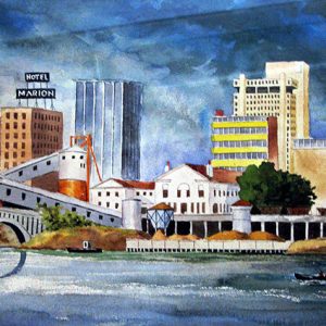 Little Rock Skyline
Little Rock to Cantonment Gibson Road
The Little Rock to Cantonment Gibson Road was constructed between 1825 and 1828 to connect Little Rock (Pulaski County) and Fort Smith (Sebastian County) to the military post at Cantonment Gibson in the Indian Territory (modern-day Oklahoma). The road was used extensively during the forced removal of Native Americans from the southeastern United States to the Indian Territory during the 1830s. On March 3, 1825, Congress approved a bill to establish a road from Little Rock to the Indian Territory, continuing the Memphis to Little Rock Road between the Mississippi River and Little Rock that was authorized a year before. In addition to the $10,000 funding, Congress appointed Arkansas pioneers Benjamin Moore of Crawford County, Morgan Magness of Independence County, …
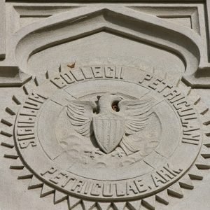
Little Rock University
Little Rock University, founded in 1882, was the second college founded in Little Rock (Pulaski County) and the first of four colleges with “Little Rock” in the name. It was a four-year, liberal arts, coeducational school for white students. According to an Arkansas Gazette article, “The Little Rock University was built by the Freedman’s [sic] Aid Society, by the Arkansas Conference of the Methodist Episcopal Church, north, and the citizens of Little Rock who contributed $10,000 towards it.” The school closed in 1894. The Freedmen’s Aid Society of the Methodist Episcopal Church, based in Cincinnati, Ohio, was formed in 1866. Its original purpose was “the relief and education of the Freedmen and people of color in general,” but the mission was …
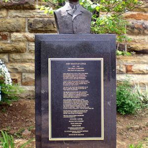 John Sebastian Little Monument
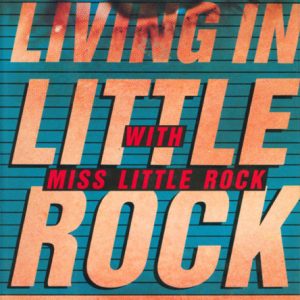 Living in Little Rock with Miss Little Rock by Jack Butler


