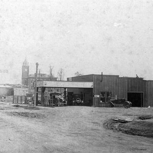
 Matthews Garage
Entry Type: Place - Starting with M
Matthews Garage
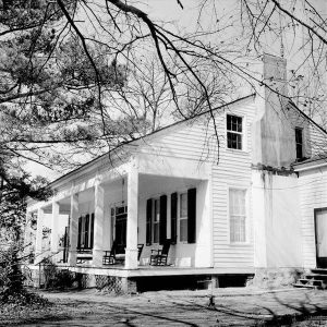
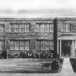 Matthews Hall
Mauldin (Montgomery County)
The former town of Mauldin, in Montgomery County, is located between Pencil Bluff (Montgomery County) and the county seat, Mount Ida. Fueled by the logging industry, Mauldin was once the largest town in the county, although twenty-first-century Mauldin is a ghost town, with little physical evidence remaining. The Caddo River Lumber Company established Mauldin around 1922 where company logging railroads in Montgomery County crossed land purchased from William Mauldin, a local homesteader. The easily accessible landscape and proximity to vast reserves of timber in the northern portion of the county created an ideal location for a logging town. Timber was easily transported by rail to the large mills at Glenwood (Pike County) or Rosboro (Pike County). There, on William Mauldin’s …
Maumelle (Pulaski County)
Maumelle is a city five miles west of Little Rock (Pulaski County) on Interstate 40. A fast-growing, affluent suburb of Little Rock, it has the highest median household income in the state of Arkansas, according to the U.S. Census Bureau. It is one of the planned communities that arose in central Arkansas during the 1970s. The area that is now Maumelle was visited by European explorers prior to the Louisiana Purchase and American settlement. Maumelle derives its name from the French word mamelle, or “breast,” probably due to the conical shape of nearby Maumelle Mountain (now Pinnacle Mountain). Identifying the early settlers of Maumelle is difficult, as they left few written records. Although a few had obtained land grants from …
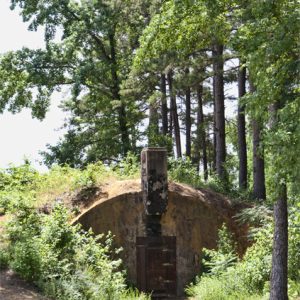 Munitions Storage Facility
Maumelle and Little Maumelle Rivers
aka: Lake Maumelle
The Maumelle River flows from small streams originating in the Ouachita National Forest in Perry County eastward to empty into the Arkansas River upstream from Little Rock (Pulaski County). Its most prominent feature is an 8,900-acre manmade lake, which supplies drinking water for ninety-five percent of the residents of Pulaski County. The river is named for a rock formation in western Pulaski County. Now called Pinnacle Mountain, it was dubbed “Mamelle” by French explorers early in the nineteenth century for the French word for “breast.” The Maumelle River flows to the north of Pinnacle Mountain; a second river, called the Little Maumelle River, flows to the south of the same mountain. Some area residents refer to the Maumelle River as …
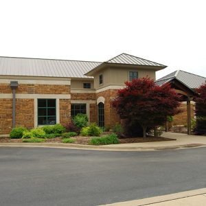 Maumelle Library
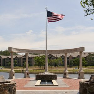 Maumelle Veterans Memorial
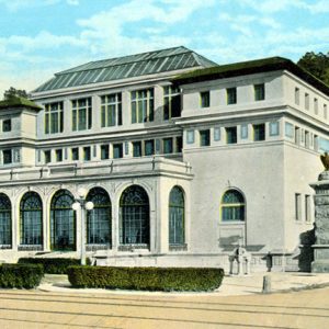 Maurice Bath House
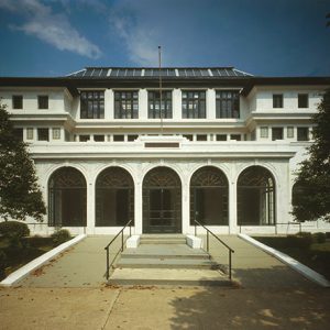 Maurice Bathhouse
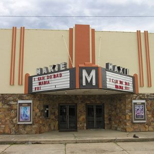 Maxie Theatre
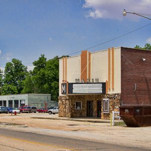 Maxie Theatre
Mayflower (Faulkner County)
Mayflower is a small town eleven miles south of Conway (Faulkner County) and twenty-five miles northwest of Little Rock (Pulaski County) on Interstate 40. Located on the southwestern edge of Lake Conway, Mayflower is known for its fishing. Like many of the smaller towns of Faulkner County, such as Vilonia and Greenbrier, Mayflower offers a rural lifestyle within a short drive of Conway and Little Rock, where many of its residents commute to work. European Exploration and Settlement The area’s earliest European settlers were Loyalists, or Tories, who moved west to escape the Revolutionary War. Families such as the Flannagins and Massengills arrived around 1778 and settled near the mouth of Palarm Creek, where they found good soil, ample amounts …
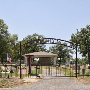 Mayflower Cemetery
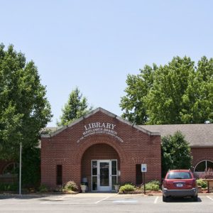 Mayflower Library
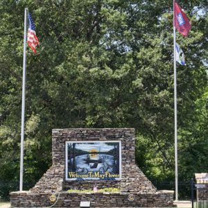 Mayflower Sign
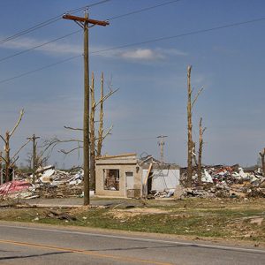 Mayflower Tornado Damage, 2014
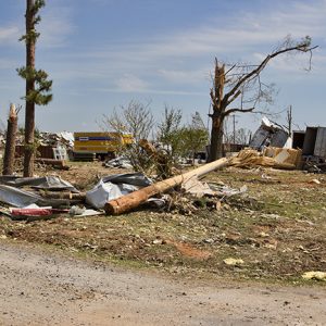 Mayflower Tornado Damage, 2014
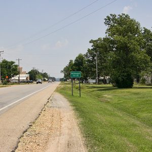
Maynard (Randolph County)
Maynard is in northern Randolph County, located at the intersection of State Highways 328 and 115. The town is known for its academic heritage and for preserving the history of the area with the Maynard Pioneer Park and Museum. Three freshwater springs have long made the area of Maynard desirable for brief refreshment or for more permanent settlement. When the United States acquired the Louisiana Purchase in 1803, Osage hunters and travelers frequented the area, although their homes were farther north in Missouri. Early highways crossed near the springs—the Old Military Road (also known as the Southwest Trail) that connected St. Louis, Missouri, to parts of the Red River valley and Texas, passed near the springs, where it intersected the …
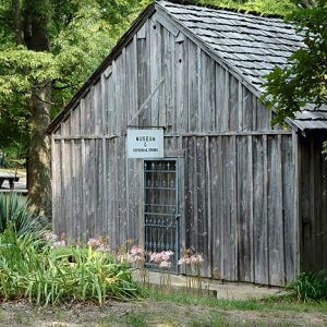
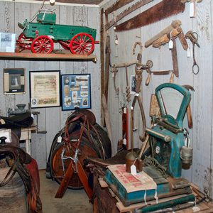
Maynard Pioneer Museum and Park
Located on State Highway 328 on the outskirts of the small town of Maynard (Randolph County), the Maynard Pioneer Park and Museum was founded in 1980. The park and museum reflect life in the Ozarks around the end of the nineteenth century, and the museum also preserves pictures, documents, and artifacts of that time. Each September, the park hosts a craft fair and festival that is attended by thousands of people. Built along the old Southwest Trail and near the historic Columbia community, the settlement of Maynard dates to the decade following the Civil War. The first businesses were a gristmill, sawmill, pharmacy, and post office. In 1894, the Abbott Institute (later the Maynard Baptist Academy) was established, drawing students …
 Maynard Pioneer Museum
 Maynard Pioneer Museum
 Maynard Pioneer Museum
 Maynard Pioneer Museum Grounds
Maysville (Benton County)
Although it is unincorporated, Maysville is one of the oldest settlements in Benton County. Located on Arkansas Highway 43 near the Oklahoma state line, Maysville is the westernmost community in Arkansas. The Osage hunted and fished in northern Arkansas until they were removed farther west by a series of treaties. The first white resident of the land that would become Maysville was Adam Beatie, who arrived in 1828. The area became known as Beatie’s Prairie, which was the name of the post office from 1840 to 1850. John Martin May arrived in 1831. The community was named for him, and the post office changed its name to Maysville in 1850. A merchant named Hugh Tigret arrived in 1838; he is …
McAlmont (Pulaski County)
McAlmont is an unincorporated community in Pulaski County, just to the east of North Little Rock (Pulaski County). Its southern boundary is Interstate 40, and the community is divided by tracks of the Union Pacific Railroad. After Little Rock had become established as the capital of Arkansas, farmers began to cultivate land north of the Arkansas River from the capital city, establishing plantations to grow cotton and subsistence crops. Among the early landowners in the region that would be McAlmont were Charles Robinson, who first acquired a land patent in 1837 and added more land in 1842; David Spence (1838); Ephraim Beasley (1838); Edward Cook (1839); Lucy Beasley (1839); Kindred Delk (1842); and Littleberry M. Robinson (1842). The Southwest Trail ran through …
McArthur (Desha County)
McArthur (Desha County) is a historic community five miles north of McGehee (Desha County) on Arkansas Highway 1. It was first named McArthur Station in honor of Zack McArthur, an early settler in the area. A post office operated at McArthur from 1907 to 1918, but the settlement was never incorporated. Because McArthur is located near Macon and Coon bayous, once navigable waterways, it was already somewhat populated when the St. Louis, Iron Mountain and Southern Railroad (later called the Missouri Pacific Railroad, then Union Pacific) completed a railroad bridge over the Arkansas River at Yancopin (Desha County) in 1904. The railroad allowed timber to be harvested, processed, and shipped out. Several stores opened, and a one-room school was constructed there …
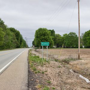 McArthur
McCaskill (Hempstead County)
McCaskill is a town in northern Hempstead County on U.S. Highway 371. It developed early in the twentieth century after construction of the Prescott and Northwestern Railroad. Although some of Arkansas’s oldest cities and towns emerged in Hempstead County along the Southwest Trail (an early military road), the northern part of the county remained remote until the start of the twentieth century. Some settlers acquired land and established farms and plantations, including Hezekiah Askew, who came from North Carolina to Pike County around 1848 before going the land office in Washington (Hempstead County) in 1860 and acquiring land around what one day would be McCaskill. His sons James and John purchased adjoining lots around the same time. The Skirmish at …
McClard’s Bar-B-Q
McClard’s Bar-B-Q is a restaurant located at 505 Albert Pike in Hot Springs (Garland County) which achieved national recognition not only for its food but also for the prominent political figures who visit the restaurant and extol its virtues, including former president Bill Clinton. Alex and Gladys McClard owned the Westside Tourist Court in Hot Springs in the 1920s, which was located west of the current restaurant’s location on Albert Pike. According to the official history of the restaurant, a destitute traveler could not pay the $10 he owed for his two-month stay at the tourist court. The traveler asked the McClards to accept a recipe for what he called “the world’s greatest bar-b-que sauce” in lieu of payment for …
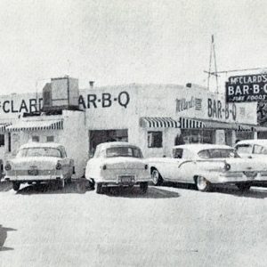 McClard's Bar-B-Q
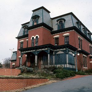
 McCollum-Chidester House
McCollum-Chidester House Museum
The McCollum-Chidester House in Camden (Ouachita County) was built in 1847 by Peter McCollum, a North Carolinian who came to Arkansas and acquired the property on a land-grant basis. It is today a museum maintained by the Ouachita County Historical Society. McCollum purchased the building materials in New Orleans, Louisiana, and had them shipped upriver to Camden by steamboat. It was the first planed lumber house in the area of Ouachita County and possibly in southern Arkansas. It boasted the first plastered walls, carpeting, and wallpaper. John Chidester, an enterprising stagecoach owner and mail contractor, purchased the home for $10,000 in gold and moved his family to Camden in 1858. Chidester wanted to expand his growing stage line farther west, using Camden …
 McCracken Drug Store
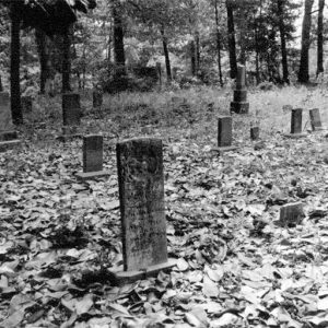 McCraw Cemetery Gravestones
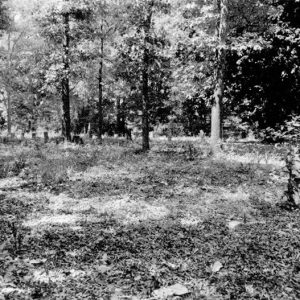 McCrew Cemetery
McCrory (Woodruff County)
McCrory is one of the many towns in northeast Arkansas that sprang up around a railroad, but the area was settled many years before its incorporation in 1890. Early Statehood through Civil War There are several versions of how the early settlement was named. As one story goes, in about 1840, a traveler riding through what is now Woodruff County stopped at a cabin in the woods to ask for directions. A woman named Jennie came to the door, surrounded by children of all sizes. Later, the traveler jokingly said he had stopped at Jennie’s Colony, referring to the multitude of children. The name stuck, and for many years the area was known as Jennie’s Colony. Another source said the …
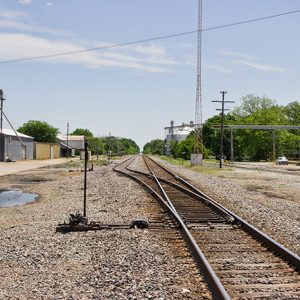 McCrory Tracks
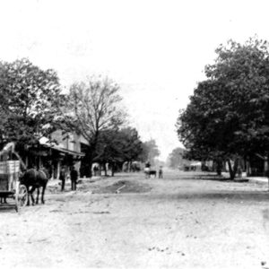 McCrory Street Scene
 McCrory Street Scene
 McCrory Street Scene
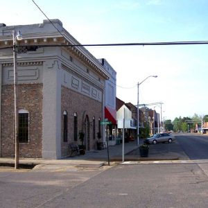 McCrory Street Scene
 McDonald-Wait-Newton House (a.k.a. Packet House)
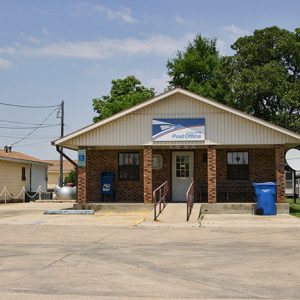 McDougal Post Office
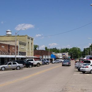
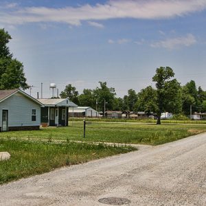 McDougal Street Scene
McDougal (Clay County)
McDougal is a city in Clay County on U.S. Highway 62 about halfway between Piggott (Clay County) and Corning (Clay County), the two county seats. Established as a railroad depot early in the twentieth century, McDougal did not incorporate as a city until 1954. Because of its location on the highway, it has survived into the twenty-first century while similar railroad towns have disappeared. Northeastern Arkansas is part of the Mississippi Alluvial Plain (commonly called the Delta). As such, the land was covered with swamps and hardwood forests when it was acquired by the United States in the Louisiana Purchase of 1803. The New Madrid Earthquakes of 1811–1812 changed the contour of the area, diminishing the interest of settlers in …
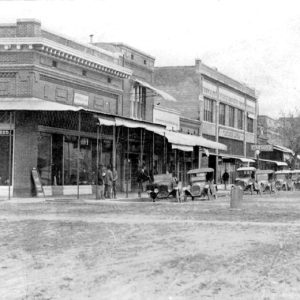
 McDougal Street Scene
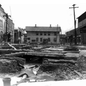 McGehee after 1927 Flood
 Wiley A. McGehee Park
McGehee (Desha County)
McGehee (Desha County) is a small town located in southeast Arkansas. It had its beginnings as a hub of transportation—the railroad branched from it in four directions. Its progress has mirrored that of the railroads, growing during the railroad boom and declining as the railroad declined. Transportation is once again bringing hopes of prosperity, with the Yellow Bend Port on the Mississippi River and the possibility of the Interstate 69 corridor—a highway connector between Quebec, Canada, and Mexico City, Mexico—becoming a reality. Louisiana Purchase through the Gilded Age Benjamin McGehee came from Alabama in 1857 and settled in southeast Arkansas in what was then Chicot County. Benjamin brought with him his wife, Sarah, and his three children. The McGehees, like …


