 Perry
Perry
Entry Category: Counties, Cities, and Towns - Starting with P
Perry
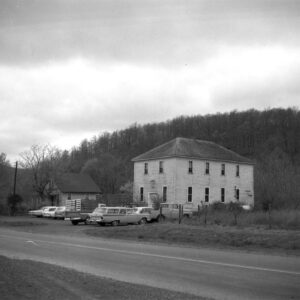
Perry (Perry County)
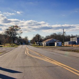
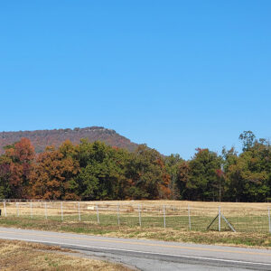
Perry is a town in Perry County that began as a railroad stop and survived as a lumber town. State Highways 9 and 10 run south as a single highway from Perry to Perryville (Perry County), but they divide in Perry, with Highway 9 running north to Morrilton (Conway County) and Highway 10 running west to Adona (Perry County). Few settlers came to the northwestern side of Perry Mountain before the Choctaw, Oklahoma, and Gulf Railroad was built in 1898. The depot built at this location was known first as North Perryville, but by the time the post office was established in 1899, the name had been shortened to Perry. Railroad workers preferred the well water of Perry to that found at …
Perry County
Perry County is in the Ouachita Mountains with the Arkansas River Valley flanking its eastern border and the Fourche La Fave River traversing it from west to east. It has six sub-basins and fourteen watersheds that include more than 800 acres of streams and lakes. The beauty of the mountains, rivers, and lakes is evident at every turn. The soil is rich alluvial in the river bottoms, and the uplands have loam with a clay foundation. The county has more than 287,000 acres of woodlands. Timber companies and the U.S. Forest Service are the major landowners. Despite the county’s central location in the state of Arkansas, the mountains and watercourses made early settlement difficult. Flood control and better roads …
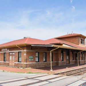
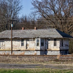 Perry Depot
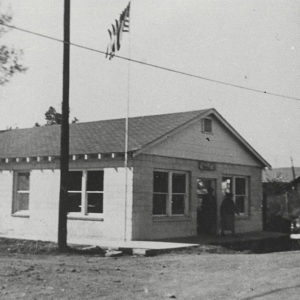
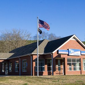 Perry Post Office
Perrytown (Hempstead County)
Perrytown is a town on U.S. Highway 67 about three miles northeast of Hope (Hempstead County). Incorporated in 1963, it is named for local businessman Perry Campbell. Parts of Hempstead County were inhabited by Caddo before the arrival of European explorers and American settlers. Among the first white Americans to claim land in the region that would become Perrytown were Robert Carrington, James Cantley, William Easley, and David Mouser, all of whom received land patents in 1837; Carrington owned the largest portion of land. By this time, the Southwest Trail had been established through Arkansas, running through such communities as Washington (Hempstead County) and Fulton (Hempstead County). The Cairo and Fulton Railroad, intended to connect southern Illinois with many cities …
Perryville (Perry County)
Perryville sits in the Fourche River valley at the base of the Ouachita National Forest. The town is encircled by four major Arkansas cities—Little Rock (Pulaski County), Conway (Faulkner County), Russellville (Pope County), and Hot Springs (Garland County), each less than an hour’s drive away. Its pristine environment and mountainous scenery make a significant statement about the area. The town is sequestered between mountains to its north and south and was first located north of the forks on the Fourche La Fave River. Louisiana Purchase through Early Statehood The shallows were a natural draw for settlers in the early 1830s, and subsequently, the Fourche La Fave Township was formed. In December 1840, the Arkansas General Assembly created the forty-fourth county …
 Perryville Fire Station
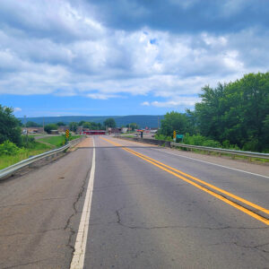
 Petit Jean Mountain
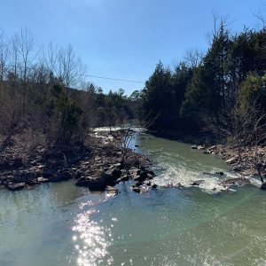 Petit Jean River
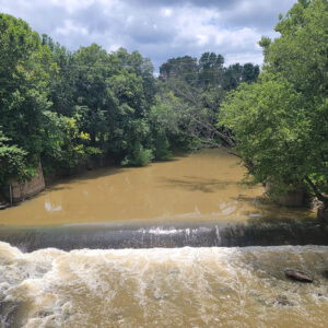 Petit Jean River
 Petit Jean River Bridge
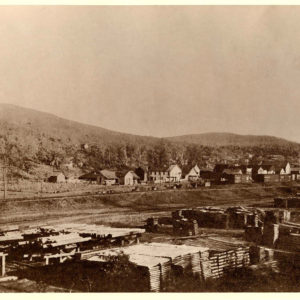
Pettigrew (Madison County)
During the early twentieth century, Pettigrew, a small Madison County town located near the White River, was known by many as the “Hardwood Capital of the World.” At its peak, the town, which was situated at the end of the railroad line, was the major shipping station for the many area timber operations. Vast acres of virgin timber and the coming of the railroad were the main factors that led to the founding and growth of Pettigrew. By the late 1880s, a small settlement had begun to develop along the White River. In about 1897, George Pettigrew, a civil engineer with the St. Louis–San Francisco Railway (Frisco), selected a track route into the timber lands and laid out the town’s …
 Pettigrew Building
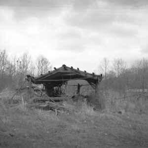 Pettigrew Mill
 Pettigrew View
Pfeiffer (Independence County)
Pfeiffer in Independence County is located just east of Highway 167 (North St. Louis Street) on Pfeiffer Road about five miles north-northeast of the county seat, Batesville (Independence County), and about eight miles south-southwest of Cave City (Sharp and Independence counties). Pfeiffer Creek is nearby. A marker at Pfeiffer reads, in part, “A light-colored crystalline limestone known as Batesville marble has been mined in this area since 1836. Pfeiffer was also a railhead with wagons coming from many points to pick up freight.” Charles Anton Pfeiffer from Baden, Sigmaringen, Germany, and his father, Joseph Pfeiffer, started the Pfeiffer Stone Company—dealers in stone, marble, and granite—on a moderate scale in 1860 in St. Joseph, Missouri. Joseph Pfeiffer and his family had …
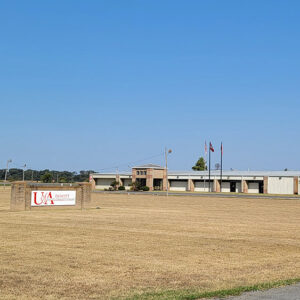 Phillips Community College; DeWitt
Phillips County
Phillips County is part of the Delta region of Arkansas. Located where the St. Francis River empties into the Mississippi River, its significance touches on nearly every aspect of the state’s history. In the twentieth century, Phillips County was known for devastating flooding, harsh racial confrontations, and the development of blues music. Phillips County’s soil consists of alluvial deposits from the Mississippi River, making it prime agricultural land. The southern edge of Crowley’s Ridge provides higher land once used by Native Americans. Helena’s location on the Mississippi River gave it the potential to be an important transportation hub, although it eventually was overtaken in importance by Memphis, Tennessee. Pre-European Exploration Because of its location, the area was well populated …
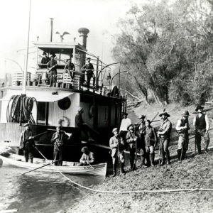 Phillips County Hunters
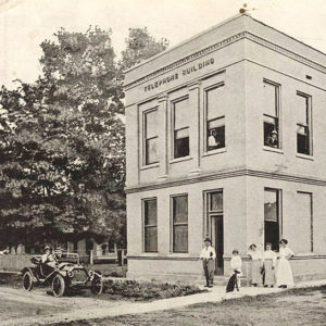 Phone Company
Pickens (Desha County)
Pickens (Desha County) is located three miles south of Dumas (Desha County). The unincorporated community was called Walnut Lake until 1932, when the name was changed to “Pickens” in honor of Burton Cecil Pickens, son of Reuben A. Pickens who settled in the area in 1881 along with his brother, William S. Pickens. The Walnut Lake/Pickens area community was established as the result of the relocation of the St. Louis, Iron Mountain and Southern Railroad from Pine Bluff (Jefferson County) to Napoleon (Desha County) in 1879. Napoleon, once the county seat, was located at the convergence of the Arkansas and Mississippi rivers. The relocation of the railroad into the interior of the county sparked the establishment of other communities along the route. A …
Piggott (Clay County)
Piggott, a thriving agricultural town in northeast Arkansas, has several claims to fame that have left their mark on the community. Among them are its relationship with American writer Ernest Hemingway, its selection as a site for filming the classic movie A Face in the Crowd, and its reputation as a “marrying mecca.” Established in 1882, the town had its origins in 1873, when Dr. James A. Piggott and some of his pioneering neighbors from Dow, Illinois, settled near the current town site. While Piggott was respected as a doctor, he endeared himself even more to his neighbors by successfully petitioning for a post office for the remote settlement. In those days, the area was dense forest broken only by …
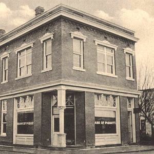 Piggott Bank
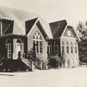 Piggott Baptist Church
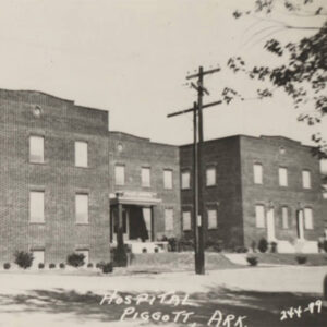 Piggott Hospital
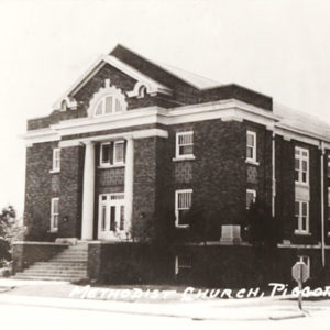 Piggott Methodist
 Piggott Post Office
Pike City (Pike County)
Pike City is in the southwest corner of Pike County approximately four miles northeast of Murfreesboro (Pike County). It is on Highway 379, a short stretch of road between Highways 26 and 27. It was originally a timber town, but little remains of the community. The town, like the county, was named for explorer Zebulon Pike. Pike City was founded in 1896 as a timber town, and settlers soon streamed in to work in the timber industry, as well as farm the land. Soon, a railroad was built from Okolona (Clark County) to Pike City. A road was built soon afterward. The Grayson-McLeod Lumber Company of St. Louis, Missouri, opened a large lumber mill, and houses and stores were built. …
Pike County
Pike County, an area of immense geological diversity, is home to the Crater of Diamonds State Park, an ancient volcanic crater and the eighth largest diamond deposit in the world. This is the only site where the public can search and keep what they find. Pre-European Exploration through Early European Exploration About 100 million years ago, during the Mid-Cretaceous period, the Gulf of Mexico extended to the middle of Pike County. The southern half of the county was under water. A volcanic explosion occurred during this period, leaving a crater of about eighty acres in area. The turbulent rotations of the earth caused diamonds to be pushed up to the surface from deep below. Not only diamonds are found here, …
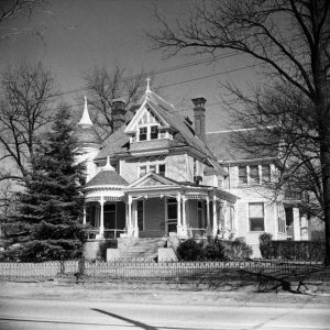 Pillow-Thompson House
Pindall (Searcy County)
Named for the acting governor of Arkansas at the time, X. O. Pindall, the town of Pindall arose along the St. Louis and North Arkansas Railroad (later the Missouri and North Arkansas Railroad) early in the twentieth century. Pindall is in the northwestern corner of Searcy County about halfway between Marshall (Searcy County) and Harrison (Boone County) on U.S. Highway 65. When European exploration and settlement began in what would become the state of Arkansas, the northern hills of the future state were claimed as hunting and fishing land by the Osage, who lived to the north. Even after treaties removed the Osage from the land, white settlers were slow to come to the rugged hills of the Ozark Mountains. …
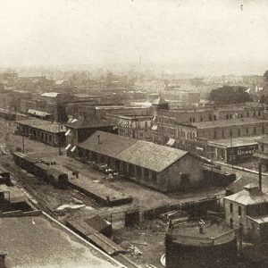
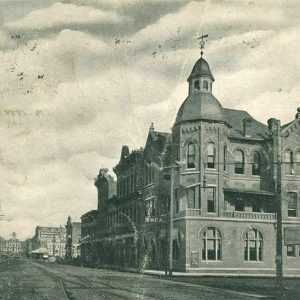
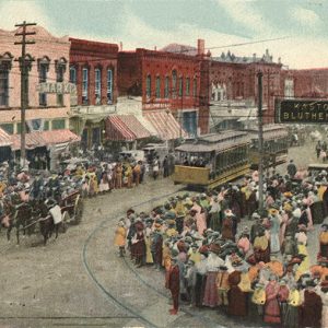
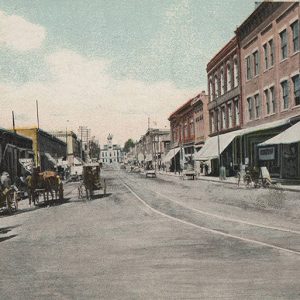
Pine Bluff (Jefferson County)
Like Jefferson County, Pine Bluff is a historical offspring of Arkansas Post (Arkansas County)—the first European foothold in Arkansas, founded in 1686 by the French and built near the mouth of the Arkansas River. The city thrived during the last part of the nineteenth century due to its status as a cotton center and river port. The city was hit hard, however, by flooding, drought, and economic depression in the early twentieth century, although World War II proved to be an economic boon to the city, which opened a munitions arsenal during the war. Despite possessing a rich history and being home to a university, the city was in decline by the beginning of the twenty-first century, facing population loss …
 Pine Bluff Automobile Club
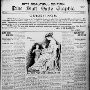 Pine Bluff Daily Graphic
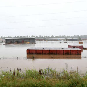 Pine Bluff Flood
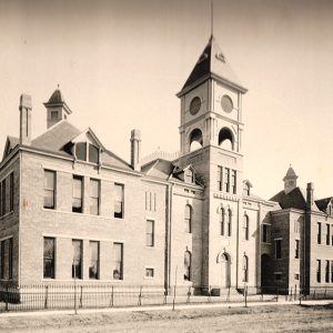 Pine Bluff High School
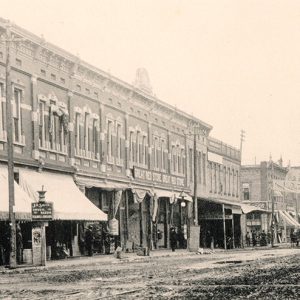
 Pine Bluff Retail District
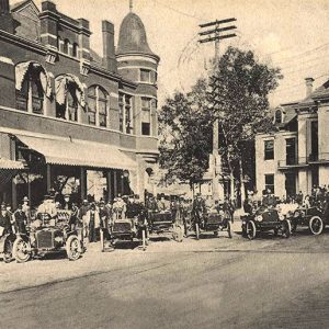
 Pine Bluff Street Scene
 Pine Bluff Street Scene
 Pine Bluff Street Scene
 Pine Bluff Street Scene
 Pine Bluff Street Scene
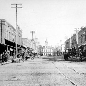 Pine Bluff Street Scene
 Pine Bluff/Jefferson County Library
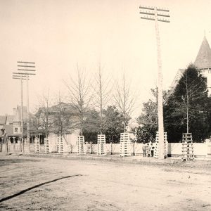
 Entering Pine Grove
Pine Log (Benton County)
The Pine Log community lies deep in the hills of the Lost Bridge area of Benton County. Union veteran Nathaniel Mattox Doke came to the area in about 1872. Families settled there at a time when northwestern Arkansas growth was starting to include post offices, churches, schools, and businesses. Railroad construction was moving westward, and farming was the livelihood for most people in the area. Nathaniel M. “Preacher” Doke owned 200 acres in Pine Log, and the White River ran through some of his acreage. (If it flooded, his crops were ruined.) He grew corn and developed orchards of peaches and apples, and had cows, hogs, and cashmere goats. Doke was a Civil War veteran, preacher, carpenter, blacksmith, and fiddler. …
Pine Ridge (Montgomery County)
Pine Ridge of Montgomery County was originally the community of Waters. The name was changed in 1936 in honor of Lum and Abner, a popular radio show set in a fictional town of Pine Ridge, which was largely based on the people and characteristics of Waters. Henry M. Waters, a local businessman who also operated a sawmill and a gin, established a post office in his small store in 1886 and named the farming and logging community Waters. From the 1880s to the early 1900s, the town’s school and church operated in the same building. In 1904, A. A. McKinzie built a general store. In 1909, James Richard (Dick) Huddleston built the Huddleston General Store, which housed the post office …
 PineBluff/Jefferson County Historical Museum
Pineville (Izard County)
Pineville, a small town located in northwest Izard County, was once a center of commerce and trade for area residents. Though most area residents farmed the land or raised cattle, timber harvesting also played a role in the growth of the settlement. Early settlers such as James, William, and Allen Whitfield were attracted to the White River valley for its rich farm land. By the 1830s, the military road that intersected with the road leading to Jacksonport (Jackson County) connected the area to the White and Black rivers, important trade routes. Robert Calvin Matthews, who settled in the area by 1860, was a major influence in the development of the settlement. He built the area’s first house and, in 1861, …


