 Marion County Map
 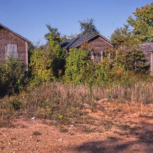 Pyatt Cabins
 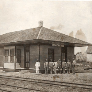 Pyatt Depot
501-918-3025
calsfoundation@cals.org
calsfoundation@cals.org
| Latitude and Longitude: | 36°14’45″N 092°50’42″W |
| Elevation: | 814 feet |
| Area: | 1.26 square miles (2020 Census) |
| Population: | 181 (2020 Census) |
| Incorporation Date: | June 11, 1929 |
Historical Population as per the U.S. Census:
|
1810 |
1820 |
1830 |
1840 |
1850 |
1860 |
1870 |
1880 |
1890 |
1900 |
|
– |
– |
– |
– |
– |
– |
– |
– |
– |
– |
|
1910 |
1920 |
1930 |
1940 |
1950 |
1960 |
1970 |
1980 |
1990 |
2000 |
|
– |
– |
254 |
224 |
257 |
144 |
137 |
217 |
185 |
253 |
|
2010 |
2020 |
|
|
|
|
|
|
|
|
|
221 |
181 |
|
|
|
|
|
|
|
|
Pyatt is a town located on Crooked Creek in Marion County. It is connected by U.S. Business Highway 62 to U.S. Highway 62, which crosses the creek a few miles south of Pyatt.
Native Americans were frequent visitors to the Crooked Creek valley before white settlers began arriving in the area. The first land survey conducted in Marion County found that the land along the creek had been cleared and planted with cotton by 1832. Settlers referred to the early settlement as Stringtown because of the way homesteads were strung along the creek. When a post office was established at the settlement in 1855, it was given the name Clear Creek. The community had a cotton gin and a steam mill, as well as a physician, J. Frank Lair.
The Crooked Creek area was spared some of the violence that other parts of Marion County endured during the Civil War, although men from Stringtown fought in the war, and guerrilla bands plagued the farms with occasional raids, leading to food shortages by the end of the war.
During Reconstruction, a public school was built in the valley and named Powell for Governor Powell Clayton. In 1888, the post office was renamed Powell after the school. Along with the school and post office, the settlement of Powell also had one store and a blacksmith shop.
Life changed for the people of the valley when the White River Branch of the Missouri Pacific Railroad (the St. Louis, Iron Mountain and Southern Railroad until 1917) was built in the early twentieth century. The railroad right-of-way was established through the valley in November 1902, and the railroad was operating by the end of 1904. The railroad passed through a cotton plantation owned by Mary Magness, and a depot was built and a town platted on her land in 1904. Residents of Powell moved to the new community, named Pyatt for a railroad engineer—thought by some to have been the section foreman. The community became prosperous in a short time, with a cotton gin, a grist mill, a general store, and several houses.
Highway construction during the 1920s made the community accessible to automobile traffic. The first industry established in the new town was a mill to plane lumber. A hotel was also operating, and a new school building was constructed in 1926. Some businesses and homes were damaged by a tornado in 1928.
The town was incorporated in 1929. During the Depression, a canning factory was established in Pyatt, processing tomatoes, apples, and blackberries. The factory was destroyed by fire in 1949. A community center was built in Pyatt in 1938.
An Assembly of God began meeting in 1937, the first church in Pyatt. A Landmark Missionary Baptist church was established in 1941, and a Church of Christ was founded in 1951. In 1973, the school districts of Pyatt and Bruno (Marion County) were consolidated. By 1977, Pyatt had completed a municipal water system. The town had two gas stations and grocery stores, a milling company warehouse, and a sand and gravel company that supplied material for the construction of Norfork Dam as well as for roads and highways in northern Arkansas.
In 2004, the Bruno-Pyatt School District was consolidated with two other districts into the Ozark Mountain School District, with schools in Eros (Marion County), St. Joe (Searcy County), and Western Grove (Newton County). In 2015, Pyatt had four businesses: an air conditioning business, a tractor business, a liquor store, and an auto repair shop. The Baptist church and Church of Christ continue to meet. The Pyatt vicinity has four listings on the National Register of Historic Places: the school building, a 660-foot railroad tunnel, and two highway bridges over Crooked Creek.
Ronald Dale Tabor, who lives in Pyatt, is a quadriplegic mouth-artist who taught himself to paint using his mouth after sustaining an injury in a near fatal car accident. He is known for his realistic paintings of rural Arkansas.
For additional information:
Berry, Earl. History of Marion County. Yellville, AR: Marion County Historical Society, 1977.
Pyatt, Arkansas. http://www.pyatt.net (accessed August 5, 2022).
Steven Teske
Butler Center for Arkansas Studies


Comments
No comments on this entry yet.