 Arkansas River Navigation Project Stamp
 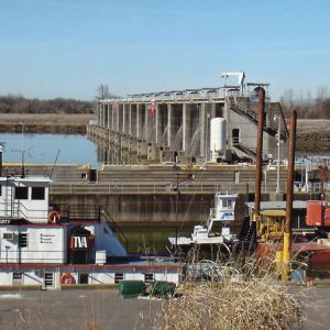 Arthur Ormond Lock and Dam
 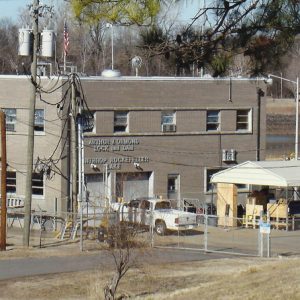 Arthur Ormond Lock and Dam
 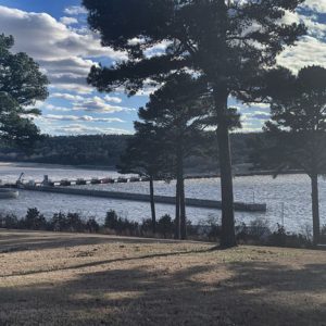 Dardanelle Lock and Dam No. 10
 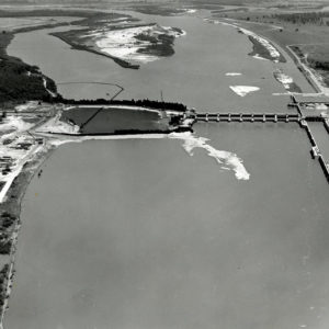 David D. Terry Lock and Dam
 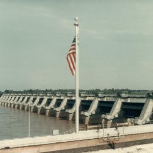 David D. Terry Lock and Dam
 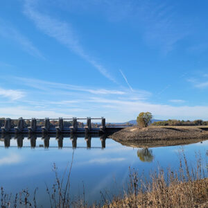 Lock & Dam No. 9
  Lock and Dam No. 5
 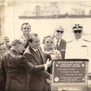 McClellan-Kerr Waterway Dedication
  John McClellan
 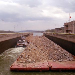 Murray Lock
 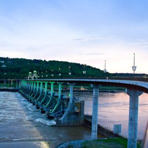 Murray Lock and Dam
  Murray Lock and Dam Overlook
 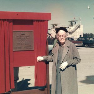 Adolphine Fletcher Terry
 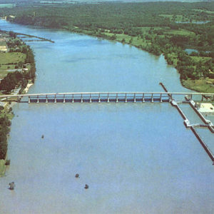 Toad Suck Bridge
 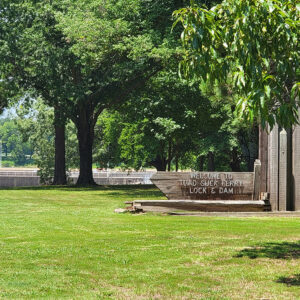 Toad Suck Ferry Lock and Dam
 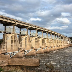 Toad Suck Ferry Lock and Dam No. 8
 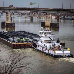 Tugboat and Barges
 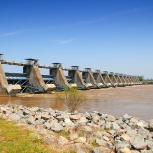 White Hall: Lock & Dam No. 5
 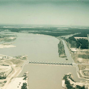 Wilbur D. Mills Dam
501-918-3025
calsfoundation@cals.org
calsfoundation@cals.org
The McClellan-Kerr Arkansas River Navigation System (MKARNS) was the largest civil works project ever undertaken by the U.S. Army Corps of Engineers at the time of its opening. Today, it is responsible for $1 billion to $2 billion in trade transportation in Arkansas each year and from $100 million to $1 billion in trade transportation in Oklahoma. Additionally, the system has numerous flood protection projects, hydro power plants, and soil conservation and recreational areas. Many communities, such as Little Rock (Pulaski County) and North Little Rock (Pulaski County), have taken advantage of the development to enhance further riverfront developments, such as the River Market and the William J. Clinton Presidential Center and Park.
At 1,460 miles long, the Arkansas River is the longest tributary in the Mississippi-Missouri River system. From its source near Leadville, Colorado, the river drops 10,000 feet in 125 miles, travels through Kansas, then through northeastern Oklahoma. There, it is joined by the Canadian, Cimarron, Neosho-Grand, and Verdigris rivers. It then crosses Arkansas, emptying into the Mississippi River in Desha County.
In the 1920s, advocates in Arkansas and Oklahoma looked to river development as an achievable goal for the future. Part of the impetus behind such development was the prevalence of flooding along the Arkansas River system. Disastrous floods had struck Oklahoma in June and October 1923. The Flood of 1927 made the Arkansas River a conduit for an eight- to ten-foot wall of water that destroyed nearly every levee downriver from Fort Smith (Sebastian County) to the Mississippi River. This led to the formation of the Arkansas River Flood Control Association (ARFCA) to lobby members of Congress for a comprehensive flood control program. The next year, Congress passed a flood control act. In July 1935, the U.S. Army Corps of Engineers informed Congress that Arkansas River navigation was technically but not economically feasible due to the high cost of the project during the financial woes of the Great Depression. Meanwhile, independent estimates put the cost for creating an Arkansas River navigation system much lower than the Corps’ figures; therefore, Congress ignored the Corps’ negative report and passed a landmark flood control act in 1936, creating the Southwestern Division of the Corps, which then began work in the upper Arkansas, Red, White, and Black river basins.
In 1946, the Arkansas Basin Development Association (ABDA) was established and led the effort for Arkansas River navigation legislation. That same year, the powerful Tri-State Committee, which handled the appropriation requests for Arkansas, Oklahoma, and Kansas, presented a waterway development program for the Arkansas River to the U.S. Congress. Among its number was Clarence Byrns, editor of the Fort Smith Southwest-Times Record. Byrns had written editorials for four decades promoting navigation on the Arkansas River.
On July 24, 1946, Congress passed the Rivers and Harbors Act authorizing the building of the McClellan-Kerr Arkansas River Navigation System (officially known as the Arkansas-Verdigris Waterway prior to legislation changing its name). The plan included hydropower, flood control, recreation, and navigation from Catoosa, Oklahoma, to the Mississippi River.
Completion of the project was not assured by passage of this act; only $55 million was authorized for initial improvements, with later funding to be approved on a year-to-year, dam-by-dam basis. Senator John L. McClellan of Arkansas and Senator Elmer Thomas of Oklahoma sat on the Senate Appropriations Committee. In 1948, Governor Robert S. Kerr of Oklahoma ran a successful campaign to become Oklahoma’s junior senator, where he joined Senator McClellan in championing waterway transportation.
The River and Harbor Act of 1948 authorized $740,000 for flood protection projects for Carthage and Monett in Missouri; $300,000 for bridges that were raised at Morrilton (Conway County), Fort Smith, and Van Buren (Crawford County); and $1 million for emergency measures including bank protection and control works at Branden Bends, Oklahoma. In 1950, Congress authorized $80 million for the Arkansas River and tributaries for work done by the Corps, $228,000 for flood protection at Des Arc (Prairie County), $5 million for emergency measures, $15 million for the prosecution of the comprehensive plan for the basin, and $37.273 million to add the Keystone Reservoir to the project while removing the Blackburn and Taft reservoirs. Also in 1950, construction started at the Oologah Reservoir. However, all of this activity stopped due to the Korean War, which refocused the work of the Corps and federal funds.
In 1954, the project was placed in a “deferred for further study” category. A major engineering problem needed to be solved: 100 million tons of silt flowing down the Arkansas annually could prevent navigation. Professor Hans Albert Einstein, son of the famous physicist, proposed a way for the river to clean itself, thus reducing sedimentary flow. Major reaches of the river would be deepened, straightened, and narrowed. This would stabilize the banks and make the river flow faster. The faster waters would flush out sediment that would otherwise settle and require constant dredging. This plan was tested by the Waterways Experiment Station in Vicksburg, Mississippi, and was found to work. The system worked so well as tested and put into practice that $31 million was stricken from the budget for three upstream dams that had been designed to trap sediment.
In 1956, Senator Kerr won funds for three reservoirs vital to the navigation system in return for throwing his support behind the popular Federal Aid Highway Act (which authorized the interstate highway system). President Dwight D. Eisenhower vetoed the bill, but his veto was overridden by Congress. Eisenhower initially refused to authorize spending the money for the project until Congressman Page Belcher, a Republican from Tulsa, explained that he might lose his seat to a Democrat in the next election were the funds not approved.
Work resumed in 1955 on the Oologah Reservoir (northeast of Tulsa) and began on the Keystone (twenty miles west of Tulsa) and Eufaula reservoirs (in east-central Oklahoma). These upstream lakes are vital to the navigation system. In addition to providing flood control, hydroelectric power, and recreation, these reservoirs were designed as a means to regulate the depth of water in the navigation channel.
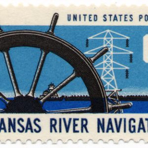
In 1958, the navigation system construction began with the construction of the Lake Dardanelle Lock and Dam. On October 4, 1968, navigation was opened to Little Rock. A U.S. postage stamp was issued bearing the words “Arkansas River Navigation” to commemorate the occasion. On January 4, 1969, the first commercial barges (from Wheeling, West Virginia, and Pittsburgh, Pennsylvania) docked at the Port of Little Rock. On December 30, 1970, the system was ready for full use. It encompassed 443 miles and seventeen locks and dams.
The Arkansas River Navigation Project provided a minimum nine-foot-deep channel with a total lift of 420 feet, 450 miles long from the Mississippi River to the head of navigation at Catoosa, near Tulsa. On January 3, 1971, the first commercial barge pulled into the Port of Muskogee, containing steel pipe manufactured by Republic Steel.
President Richard M. Nixon was the keynote speaker for the dedication of the McClellan-Kerr Arkansas River Navigation System at the Tulsa Port of Catoosa on June 5, 1971. Senator McClellan, Congressman Wilbur D. Mills, and Speaker of the House Carl Albert of Oklahoma were in attendance. The system handles millions of tons of products every year, providing cost savings to hundreds of companies using water transportation.
Each of the system’s eighteen locks has a single chamber measuring 110 feet wide and 600 feet long. This is large enough to accommodate several vessels or a single tow as large as 108 feet wide by 585 feet long. A typical tow of eight barges carrying 12,000 tons total is equivalent to 400 semi-trucks or 120 railroad freight cars. Tows with more than eight barges can now be accommodated through locks that are equipped with a two-haulage system.
The maximum lift from one navigation pool to another ranges from only fourteen feet at Lock No. 4 near Pine Bluff (Jefferson County) to as much as fifty-four feet at the Dardanelle Lock. The locks are operated twenty-four hours a day and handle both commercial barges and recreational vessels. Ninety-eight percent of the time, bridges over the channel have a minimum vertical clearance of fifty-two feet. Actual vertical clearance above the normal level of the navigation pool is typically more than fifty-two feet.
The benefits of MKARNS have included flood control, hydropower, navigation, water supply, wildlife conservation, and recreation. According to the U.S. Army Corps of Engineers, flood control benefits alone prevented more than $1.3 billion in damages from 1974 through 1987. More than one billion kilowatt hours of electricity are produced annually at one half the cost of electricity produced by coal, ensuring that the region’s power costs are competitive nationwide.
In 2010, MKARNS was given “connector” status by America’s Marine Highway Program, a program established in 2008 and led by the Department of Transportation. This designated MKARNS as a secondary system connecting to the Mississippi River. In March 2015, the Corps of Engineers redefined MKARNS from a moderate-use system to a high-use one. This was followed in May with the announcement that it had been upgraded to “corridor” status by the Marine Highway Program and designated Marine Highway 40. This upgrade increased the opportunities for federal assistance for system maintenance and improvements.
In 2023, the U.S. Army Corps of Engineers started on planning and design work aimed at deepening the shipping channel of the Arkansas River along the MKARNS corridor to twelve feet. On August 24, 2023, ground was broken on the first phase of a project, dubbed Three Rivers, designed to prevent any merging of the White and Arkansas rivers near where they both empty into the Mississippi River.
MKARNS System Locks and Dams
| Lock/Dam | Location | Started/Completed |
| Arthur V. Ormond Lock and Dam No. 9 | Morrilton (Conway County) | 1965/1969 |
| Choteau Lock No. 17 | Porter, Oklahoma | 1967/1970 |
| Dardanelle Lock and Dam No. 10 | Russellville (Pope County) | 1957/1969 |
| David D. Terry Lock and Dam No. 6 | Scott (Pulaski and Lonoke Counties) | 1965/1968 |
| Emmett Sanders Lock and Dam No. 4 | Pine Bluff (Jefferson County) | 1964/1968 |
| J. W. Trimble Lock and Dam No. 13 | Barling (Sebastian County) | 1965/1969 |
| Joe Hardin Lock and Dam No. 3 | Altheimer (Jefferson County) | 1963/1968 |
| Keystone Dam | Keystone Lake, Oklahoma | 1956/1964 |
| Colonel Charles D. Maynard Lock and Dam No. 5 | Tucker (Jefferson County) | 1964/1968 |
| Montgomery Point Lock and Dam | Tichnor (Arkansas County) | 1998/2004 |
| Murray Lock and Dam No. 7 | Little Rock (Pulaski County) | 1964/1969 |
| Newt Graham Lock No. 18 | Inola, Oklahoma | 1967/1970 |
| Norrell Lock and Dam No. 1 | Tichnor (Arkansas County) | 1963/1967 |
| Norrell Lock No. 2 | Tichnor (Arkansas County) | 1963/1968 |
| Ozark-Jeta Taylor Lock and Dam No. 12 | Ozark (Franklin County) | 1964/1969 |
| Robert S. Kerr Lock and Dam No. 15 | Sallisaw, Oklahoma | 1964/1970 |
| Toad Suck Ferry Lock and Dam No. 8 | Conway (Faulkner County) | 1965/1969 |
| W. D. Mayo Lock No. 14 | Spiro, Oklahoma | 1966/1970 |
| Webber Falls Lock and Dam No. 16 | Gore, Oklahoma | 1965/1970 |
| Wilbur D. Mills Dam No. 2 | Dumas (Desha County) | 1963/1968 |
For additional information:
Bolton, Charles S. 25 Years Later: A History of the McClellan-Kerr Arkansas River Navigation System in Arkansas. Little Rock: U.S. Army Corps of Engineers, Little Rock District, 1995.
Congressman Wilbur D. Mills Public Papers. Hendrix College Archives. Bailey Library. Hendrix College. Conway, Arkansas.
Cook, Marty. “River Highway.” Arkansas Business, July 17–23, 2023, pp. 1, 10–11.
Daniels, Alex. “Keeping McClellan-Kerr Current.” Arkansas Democrat-Gazette. February 26, 2007, pp. 1A, 6A.
———. “A River of Commerce.” Arkansas Democrat-Gazette. February 25, 2007, pp. 1A, 12A–13A.
Laymon, Sherry. “John McClellan and the Arkansas River Navigation Project.” Arkansas Historical Quarterly 69 (Summer 2010): 140–169.
Nelson, Rex. “Rollin’ on the River.” Arkansas Democrat-Gazette, December 9, 2018, pp. 1H, 6H.
Oztanriseven, Furkan, Heather Nachtmann, and Samareh Moradpour. “Economic Impact of Investment Scenarios in the McClellan-Kerr Arkansas River Navigation System.” Journal of Marine Science and Engineering 10, no. 7 (2022). Online at https://doi.org/10.3390/jmse10070923 (accessed July 26, 2022).
Senator John L. McClellan Collection. Riley-Hickingbotham Library Special Collections. Ouachita Baptist University, Arkadelphia, Arkansas.
Snyder, Josh. “Start Celebrated in Three Rivers Waterway Plan.” Arkansas Democrat-Gazette, August 25, 2023, pp. 1B, 5B. Online at https://www.arkansasonline.com/news/2023/aug/25/us-army-corps-of-engineers-holds-groundbreaking/ (accessed August 25, 2023).
U.S. Army Corps of Engineers, Little Rock District. http://www.swl.usace.army.mil/ (accessed August 18, 2023).
Kay C. Goss
Alexandria, Virginia


Praise the Lord for the visionaries who dreamed big for waterway transportation! These American citizens persevered and problem-solved flooding, silt, funding, and political issues to see this God-given dream to fruition! These citizens set a virtuous example of responsible stewardship regarding natural resources, wildlife, and most importantly the flourishing of human life. Thank you to all involved in this remarkable project!