 Environment
501-918-3025
calsfoundation@cals.org
calsfoundation@cals.org
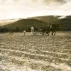
As one of three naturally occurring prairies located near Fort Smith (Sebastian County), Massard Prairie was first described in Thomas Nuttall’s A Journal of Travels into the Arkansas Territory During the Year 1819. The prairie gave its name to a community that is now within the city limits of Fort Smith; the prairie itself has largely been developed and is no longer recognizable as such. These prairies were described and mapped well before the Louisiana Purchase.
According to local tradition, Massard Prairie takes its name from T. Jean Massard, a French captain whose land grant was approximately 18,000 acres, the northern boundary being the Arkansas River. It was laid out in a French fashion called “longlots,” with strips of land along the river being as much as ten times as long as they were deep (inland). This provided more river frontage to attract the hoped-for settlers. This grant was later redistributed when Spain gained the area. In a thesis published in 1941, Minnie Armstrong reported that the actual Massard Prairie area was approximately 10,360 acres. This conformed closely to the report of Leo Leasquereux, a geologist who made a survey in 1856 in reference to coal in the area. Also, Charles S. Sargent mapped the vegetation of Arkansas in 1880, in which he delineated the forest and prairie areas. Massard himself is not known to have ever visited the area.
At the time of the Louisiana Purchase, the Osage claimed as their hunting grounds much of the land north of the Arkansas River, and they hunted the prairie areas until they were removed upriver to Kansas by the United States government. When the pressures mounted to move the Eastern Cherokee to Arkansas Territory, a number of Cherokee voluntarily moved to the area. At that time, they established farms on both sides of the river. One estimate is that there were as many as 4,000 Cherokee from Fort Smith to Dardanelle (Yell County), including Massard Prairie. Then, due to pressure of white settlers, the Cherokee were forced to move north of the river. Land in northwest Arkansas was given to the Cherokee in 1817, and whites were actually removed from the northern area. This reservation lasted until the Cherokee were moved to Indian Territory (present-day Oklahoma).
Aaron Barling, a retired soldier from Fort Smith, was one of the first to purchase land in this area legally, and his tavern was a regular stopover for people en route to Little Rock (Pulaski County). Barling was among those soldiers employed at constructing or supervising the building of the military road from Memphis to Indian Territory, which was authorized in 1825 and completed three years later. This road roughly followed the river through Massard Prairie; it later became Arkansas State Highway 22. Barling subsequently retired and became a prominent citizen of Fort Smith. He then purchased the land on the prairie and moved there soon after.
There were actually two communities using the name Massard, with their own schools and churches. One was on the southeast edge, near Steep Hill, and the second was on the Little Rock Road. In 1877, the community on the Little Rock Road was officially awarded a post office. Neal Sharum was appointed postmaster and had a section in his general store for this operation. The other Massard was renamed Maness after a long-time resident family of the prairie. Maness was in existence until the federal government took all the area south of what is now Zero Street for Fort Chaffee.
The only undeveloped portion left of the original Massard Prairie is at the site of the Civil War–era Action at Massard Prairie. One local tradition holds that the fighting occurred at an area called Diamond Grove, though the city of Fort Smith chose to commemorate the Civil War action at another site where, apparently, a hurried defense line was established. Belt buckles, buttons, and other small artifacts have been recovered from the site, although no large archaeological remains have been preserved, since this was not a fortified position.
In 1901, the state’s first well was drilled for the mining of natural gas in the area; however, an attempt to expand production using dynamite blew it up. The entirety of Massard Prairie was underlain with coal and mined extensively for a number of decades. Many old mine tunnels still remain beneath the land.
Massard’s school was open and running by the 1880s, based on the history of the Methodist church, which first met in the school. One picture noted it as “Massaraet School” using an old French variant of Massard. The building was used for both a school and church until 1910. A new Methodist church was built, and the old building continued as a school until the 1920s. At that point, the familiar two-room brick schoolhouse was built by James Clifford Patterson in exchange for the old school building, which was his home for many years. The Methodist church built in 1910 burned in the early years of the Depression. Short of funds, the congregation rebuilt it of plain frame construction on piers. By 1939, it was remodeled and became the old familiar church on the highway until 1993, when the Methodist church sold the property.
By the time that nearby Barling (Sebastian County) was becoming a town in the 1950s, Massard remained a rural community. The familiar two-room brick schoolhouse was shut down in the early 1960s, with Massard schools being incorporated into the Fort Smith school system. Fort Smith then built a new junior high school on Massard Road and named it after Lawrence Adrian (L. A.) Chaffin, an early and long-time teacher at Massard who was instrumental in an agreement with Fort Smith schools to allow Massard kids who finished eighth grade there to attend Fort Smith schools without paying tuition. When Fort Smith built a new junior high at Massard in 1969, it was named after Chaffin.
By the beginning of the twenty-first century, almost the entire area had been developed, becoming nearly indistinct from the rest of Fort Smith. Among the few remnants of the name of Massard are Massard Road and a shopping center called Massard Crossing.
For additional information:
Armstrong, Minnie Ruth. “A Study of the Flora of Massard Prairie with Some Ecological Notes.” MS thesis, University of Arkansas, 1941.
The Goodspeed Histories of Sebastian County, Arkansas. Columbia, TN: Woodward & Stimson Printing Co., 1977.
Nichols, Cheryl. “Construction of the Military Road between Little Rock, Arkansas and Fort Gibson, Oklahoma” Little Rock: Arkansas Historic Preservation Program, 2003. Online at http://www.arkansaspreservation.org/pdf/publications/Military_Road.pdf (accessed April 5, 2022).
Claude “Buddy” Patterson
Mena, Arkansas


Comments
No comments on this entry yet.