 Louisiana Purchase Historic State Park Marker
501-918-3025
calsfoundation@cals.org
calsfoundation@cals.org
The purchase of the vast Louisiana Territory from France in 1803 practically doubled the size of the United States, yet little of it was marked off by the American land survey method, which divides land into square tracts, an orderly prerequisite for land ownership in the nineteenth century. The survey of this vast, new American West began in what would later become the state of Arkansas and is commemorated at Louisiana Purchase State Park on U.S. Highway 49 between Brinkley (Monroe County) and Helena (Phillips County). Since Arkansas was first, the survey enabled early sale of land that contributed to Arkansas’s being the third state admitted into the Union west of the Mississippi River (after Louisiana and Missouri).
The survey of the Louisiana Purchase, ordered during the administration of President James Madison, began shortly after the end of the War of 1812, in part as a means for the federal government to pay its veterans with land. The nation’s greatest asset was land west of the Mississippi River, and it was necessary to survey that land so that it might be apportioned fairly to veterans and sold to settlers and other investors who were already streaming into the trans-Mississippi West.
The system used to survey Arkansas and other land of the Louisiana Purchase was the U.S. Public Land Survey System, which Congress had originally adopted at President Thomas Jefferson’s urging in 1785 to survey lands in the Ohio River Valley; previously, a method called “metes and bounds” used landmarks—such as rivers, mountaintops, and even barns—to describe the boundaries of land. The rectangular survey system lays out one-square-mile tracts called sections, which have north, south, east, and west boundaries. Three two-million-acre tracts were surveyed after the War of 1812. Two tracts were east of the Mississippi River, and one was west in the Louisiana Purchase. The latter lay generally between the Arkansas and White rivers of eastern Arkansas. The Arkansas tract was chosen for veterans and settlers because the area was well known to the French and Spanish settlers who had lived in the area near or at Arkansas Post (Arkansas County), the first European settlement west of the Mississippi.
The official land survey of the Louisiana Purchase began in October 1815, when two land surveyors, Prospect Robbins and Joseph Brown, set out on their journey from the Mississippi River. (Brown later became Surveyor General of Missouri for a brief period and surveyed the boundary between Arkansas and Missouri. Little is known about the surveyors except that they lived near Clayton, Missouri, outside present-day St. Louis.) Robbins began at the mouth of the Arkansas River and surveyed due north. Brown began several miles upstream at the mouth of the St. Francis River and proceeded due west. Brown’s survey line is called the baseline, and Robbins’s line is called the Fifth Principal Meridian because it was the fifth north-south line surveyed in the U.S.
During this time period, surveying land was exceptionally difficult work. Using only a compass and a chain, surveyors made their way through the wilderness, stopping every half mile to mark or “blaze” a tree. They carried all of their provisions with them for a task that lasted several months. In the vast wilderness of the Arkansas Delta where Robbins and Brown worked, the only signs of life were scattered Indian and animal trails.
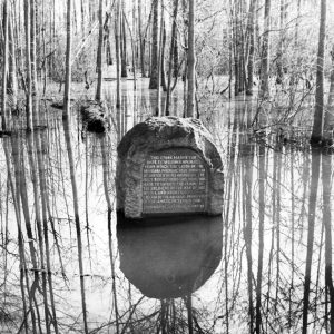
On November 10, 1815, Robbins crossed the baseline that had been set by Brown, who had already proceeded to the west of that point. Robbins sent for Brown, who returned to mark this intersection of their surveys as the Initial Point of the first survey of the American West. From this Initial Point, which is located in a headwater swamp at the northwest corner of Phillips County, the lands in Arkansas, Missouri, Iowa, North Dakota, and part of Minnesota and South Dakota are measured. This Initial Point is located in Louisiana Purchase State Park. Brown’s survey line today marks the northern boundary of Phillips County. He continued west to the Arkansas River on December 4, 1815, while another surveyor continued the baseline across what is now known as Baseline Road in Little Rock (Pulaski County). Robbins traversed the western boundary of Phillips County and continued north, reaching the present-day Missouri border later that month and continuing onward to the Missouri River, where other surveyors continued the meridian to the Canadian border.
Several other surveyors followed Robbins and Brown, marking the corners of each square mile using the Initial Point as their reference. The process took many years, and some surveys were still not complete when Arkansas joined the Union in 1836.
For additional information:
Handbook for Arkansas Land Surveyors. 2nd ed. Little Rock: Arkansas Geological Commission, 1981.
Smith, David A. “Preparing the Arkansas Wilderness for Settlement: Public Land Survey Administration, 1802–1836.” Arkansas Historical Quarterly 71 (Winter 2012): 381–406.
White, Albert C. A History of the Rectangular Survey System. Washington DC: U.S. Department of the Interior, 1983. Online at https://www.blm.gov/sites/blm.gov/files/histrect.pdf (accessed September 27, 2022).
John P. Gill
Little Rock, Arkansas


It’s amazing that we have a system today, based on what these heroes did that long ago, and considering the meager tools they had to work with. I live in Minnesota and have been to the first marking that established the Minnesota-Iowa border, and have the same feelings about this accomplishment. So many things to learn, so little time!