 Knowlton Landing
 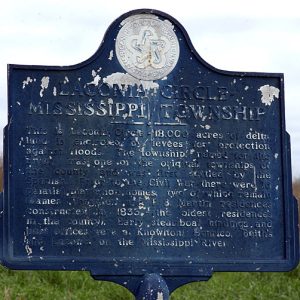 Laconia Circle Levee Monument
501-918-3025
calsfoundation@cals.org
calsfoundation@cals.org
The Laconia Circle Levee is situated in the southeast corner of Mississippi Township in Desha County. The levee’s circular construction is so unique that Believe it or Not, a syndicated newspaper publication for the unusual, featured the levee in one of its 1970s publications. The levee encircled Laconia Circle, which consisted of 18,000 acres of Delta land located in Desha County, for protection against potential flooding from the Mississippi and White rivers. It was the first levee in the Arkansas Delta to be affected by the Flood of 1927.
Before the Civil War, fourteen plantation homes were protected by the levee. The levee and the township were named after the Laconia Landing, one of the most active steamboat landings on the Mississippi River at the time. Desha County’s levee system is separated into two parts. The levees of Mississippi Township make up the northern part, with the remaining levees making up the southern part.
The construction of the levee began in the 1830s when Francis J. Keene, reportedly a New York lawyer or banker, along with his brothers-in-law Notley Maddox Flournoy and Thompson Breckinridge Flournoy, acquired more than 3,000 acres of land in what later became Mississippi Township. With the use of slave labor, the early settlers constructed private levees, some two to three feet high, around the township. Eventually, the levees were connected to form the Laconia Circle Levee, which continued as a private levee until the passage and approval of Act 138 of 1859; this act created the first publicly financed levees. After the Civil War, the Arkansas General Assembly enacted Act 7 of 1886, establishing the Laconia Circle Levee District. The district consisted of a small portion of Mississippi Township, to be governed by the county’s levee laws. In 1893, the state legislature expanded the Laconia Circle Levee District to include all of Mississippi Township and certain neighboring sections of Phillips County. The expansion authorized the district to issue a two-percent levee tax and employ convicts for construction and repair of the levee. In 1917, the Arkansas General Assembly passed Act 463, permitting the Laconia Circle Levee District to issue bonds, not exceeding $300,000, for payment of unsettled debts and levee improvements. Mississippi Township levees are owned by the Laconia Circle Levee District and the White River Drainage and Levee District. The towns of Snow Lake (Desha County) and Laconia (Desha County) were located within the Laconia Circle Levee. While little now exists of Snow Lake, the former Laconia is farmland.
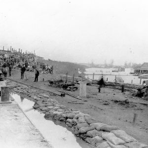
The Laconia Circle Levee was breached by flood waters in 1882, 1897, 1890, 1903, 1927, and 1937. By the Flood of 1927, the levee was almost 100 years old, making it the oldest levee in Arkansas. By late March 1927, the Laconia Circle Levee was showing signs of deterioration from the continuous heavy rainfall. Government snag boats were sent to Laconia Circle to monitor the failing levee. The boats were positioned close to the levee shoulder, which was the backbone of the structure. The shoulder rose above the levee proper and was rapidly weakening from holding back the fifty-one-foot flood stage of the Mississippi River.
On March 29, a snag boat anchored near the levee sounded the first alarm, notifying the community of an impending break. The plantation bells of the circle assumed the distress call, and the residents of the area, consisting of plantation owners and tenant farmers, began the evacuation to safe ground.
Many refugees made their way to the Snow Lake depot, where a Missouri Pacific passenger train waited to transport them from the area. The train was ordered to take passengers even if they did not have money for the fare. The Arkansas Gazette reported refugees being transported to camps in Helena (Phillips County) and McGehee (Desha County). Approximately 2,000 residents of the Laconia Circle area were evacuated. Many were housed in Missouri Pacific boxcars due to a tent shortage.
Approximately 200 men worked for more than twelve hours to save the Laconia Circle Levee. At midnight on Tuesday, March 30, the levee seemed to be holding; however, a few minutes later, a large section of the levee sloughed off into the river. It was evident to the work crew that the levee was failing, and the remaining government boats sounded the distress call again, warning any stragglers in the circle of the levee’s demise. The levee quickly broke apart. By 2:00 a.m., it had given way completely. The rushing waters of the Mississippi River left a hole more than 300 feet long in the levee wall. Within a couple of hours, the entire Laconia Circle was inundated with flood waters up to twenty feet deep in some areas. The circle was transformed into a huge vat where the water stayed throughout the summer and far into the fall, too late to recover the land for planting.
The Flood of 1927 destroyed much of Mississippi Township’s landmarks and residences. Of the fourteen antebellum plantation homes located within the Laconia Circle Levee, only the Keene-Thornton home and P. B. Martin home survived the flood. In 1976, the Desha County Historical Society erected a historical marker for the Laconia Circle Levee near the Keene-Thornton residence. In 1989, the Thornton home was destroyed by a fire, but the marker remains. As of 2010, all the land within the Laconia Circle Levee is privately owned. The levee still exists, and the U.S. Army Corps of Engineers plans, in 2010, to raise the levee in three places to meet current height regulations.
For additional information:
“History of Snow Lake.” Desha County Genealogical Website. http://www.rootsweb.ancestry.com/~ardesha/snowlake.htm (accessed on March 9, 2022).
“History of Snow Lake.” Programs of the Desha County Historical Society 1 (1973): 1–3.
Jones, James Michael. “From Ireland to Snow Lake.” Desha County Historical Society 10 (Spring 1984): 5–21.
———. “The Keene-Thornton Plantation.” Programs of the Desha County Historical Society 16 (Fall 1991): 52–64.
Merritt, Jim. “The 1927 Flood: The County’s Worst Disaster.” The ’27 Flood in Desha County, Desha County, Arkansas Historical Society 2.2 (1976): 4–21.
Merritt, Jim, and B. Gill Dishongh Sr. “The Levee System of Desha County, Arkansas.” Programs of the Desha County Historical Society 14 (Spring 1988): 7–25.
“Laconia Levee Gives Way and Flood Results.” Arkansas Gazette. March 31, 1927, pp. 1, 8.
“Levee in Desha County Rapidly Sloughing Away.” Arkansas Gazette. March 30, 1927, pp. 1, 13.
Rachel M. Miller
Arkansas Historic Preservation Program


My great-grandfather, James Buchanon Thornton, owned the Keene-Thornton home and plantation beginning in the 1890s. Later, my grandfather, James Presley Thornton, lived there with his wife Annie Laurie Whitson Thornton of Water Valley, Mississippi, until her death in 1928. He later remarried and continued to farm on the property until his death 1963. Our family owned the property until 1987 when we sold the house and property.
I went to school at Snow Lake in the 1950s. Mr. Britt was my teacher in a one-room schoolhouse set high off the ground.