 Current River
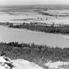 Geography and Geology
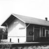 Portia (Lawrence County)
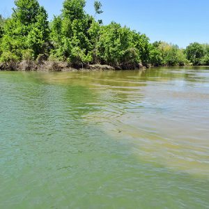 Black and White Confluence
 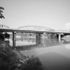 Black River Bridge
 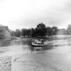 Black River Ferry
 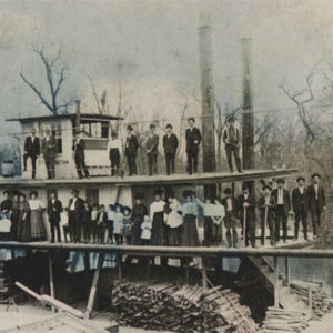 Choctaw Steamboat
 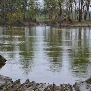 Lockhart Ferry Site
 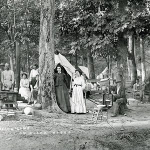 Pearling Camp
 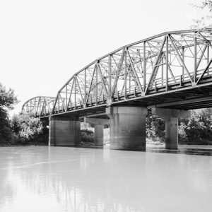 Pocahontas Bridge
501-918-3025
calsfoundation@cals.org
calsfoundation@cals.org
The Black River has played a significant, but shifting, role in the lives of residents of northeast Arkansas. For the early Native Americans who lived in the area, it was an essential food and transportation source. This remained true for European settlers in the days before roads and railroads. The river was also an essential “highway” for the flatboats and river steamers that transported people and goods to and from the area. The river supported the development of local industry as the means for moving timber from the forests to places such as the Sallee Brothers Handle Mill in Pocahontas (Randolph County), while mussel fishing supplied pearls and mother of pearl for the local button-making industry for many years. While the river no longer functions as a means of transportation, it continues to be an important recreational site for hunting, fishing, hiking, bird watching, boating, and more. Batesville (Independence County) lawyer and writer “Fent” Noland stated in 1839, “The country up White River and the Black is destined to be the finest in Arkansas. Nature has done all she could—man will do the rest.”
The Black River’s source is in southeast Missouri. It is formed from three rivers, flows south, and crosses the Arkansas border in Clay County northeast of Corning. From there, it flows generally southwest and passes through the Dave Donaldson Black River Wildlife Management Area (WMA), through Randolph County to Pocahontas, and down to Davidsonville Historic State Park. It crosses into Lawrence County just above the town of Black Rock and continues southwest to the community of Powhatan (Lawrence County). From there, it flows south through the Shirey Bay–Rainey Brake WMA, crosses the southern border of Lawrence County, and forms the east-west border between Independence and Jackson counties. It finally turns southeast and enters the White River at Jacksonport (Jackson County), just north of Newport (Jackson County). Its Arkansas tributaries are the Little Black, Spring, and Strawberry rivers, and with its connection to the White River, it is part of the Mississippi River watershed. The Black has numerous sharp bends, many with colorful names, such as Deadman and Hole in the Wall in the Davidsonville Historic State Park area, along with the Box Factory, Battle Axe, and Dead Mule bends in the lower course of the river.
The river and the WMAs through which it flows provide abundant opportunities for hunters, fishermen, hikers, and wildlife watchers. The main species of fish within it are largemouth bass, crappie, and catfish. Duck, squirrel, deer, rabbit, and turkey hunting are popular along its course, and both the Donaldson and Shirey Bay WMAs offer fine green tree reservoir (woodland duck pond) habitat. There is also a population of furbearers such as beaver, muskrat, mink, and raccoon. Numerous bald and golden eagles winter around Lake Ashbaugh in the Donaldson WMA and can be sighted on or around the lake from November through February.
The Black and its surrounding area have a fascinating history, being first inhabited by pre-Columbian mound builders, then by the Osage and Cherokee. The first European settlers were French. In the days before railroads penetrated the area, flatboats and steamboats were essential to moving people and goods, offering the only “farm to market” transportation. The first steamboat to go up the Black River to Pocahontas was the Laurel in 1829. Davidsonville, Powhatan, Pocahontas, and Jacksonport were important steamboat ports, and by the turn of the century, some forty-three steamboats traveled the river. One was the Idlewild, which is still in service at Louisville, Kentucky, having been rebuilt and renamed the Belle of Louisville. The first train arrived in Pocahontas in 1896, and the railroads gradually replaced river traffic. As late as the 1920s, however, steamboats and snag boats (used to clear river debris) were still in operation.
In earlier days, the Black River had a large population of river mussels. In 1897, Dr. J. H. Myers found a large ball pearl two miles north of Black Rock. This led to a “pearl rush,” and tent camps sprouted along the river. The shells provided mother of pearl, and Myers, with others, established a button factory at Black Rock three years later. According to Myers, this was the first button factory in the South. Area museums, such as the Randolph County Heritage Museum, have button-making tools and shells from which the buttons were cut. Pearl button manufacturing reached its peak in the mid-1940s. Overharvesting and silt in the river caused by farming and dredging have drastically reduced the mussel population. This, along with a decreased demand for mother of pearl due to the invention of plastic buttons and the zipper, virtually ended the pearling and button industries in the mid-twentieth century. However, a small number of “shellers” still gather mussels. They cut the shells into small pellets of mother of pearl for export to Asia, to be used in the cultured pearl industry.
The river has always been prone to flooding, and crossing it proved a challenge in years past. For many years, people traveling for spring terms of court between Corning and Piggott, the two county seats in Clay County, were forced to ride a train to Poplar Bluff, Missouri, and then catch the next morning’s train to the other courthouse. Flooding has been cited as one cause of the demise of Davidsonville and was partly responsible for a light voter turnout in the area when the proposed Arkansas Constitution of 1918 was defeated at the polls. Flooding has continued to this day, with severe flooding occurring in 2008 and 2011.
In early years, the State of Arkansas had no money to build infrastructure, so counties granted licenses to ferry operators and bridge builders, who privately financed the improvements and charged a toll. The first bridge at Powhatan, a flimsy swing bridge, was so operated. In 1938, Governor Carl Bailey, dedicated to removing all toll bridges in Arkansas, purchased rights to an existing ferry site just up the river. The state then used highway signs to divert traffic from the bridge. Because toll revenue dropped, the owner sued, winning at the trial level. While the case was on appeal, the parties settled, and the state paid the owner $68,000 for the bridge, which was later replaced by a safe structure. Today, five highway and four railroad bridges cross the river. The Black River Bridge at Pocahontas, built in 1934, is listed on the National Register of Historic Places. In May 2015, a new bridge spanning the Black River was opened at Black Rock, replacing the 1949 structure, which had been declared deficient by highway officials in 2010.
Many artifacts, photographs, and historical records showing industry and life on the river are on display at Davidsonville Historic State Park, the Powhatan Courthouse, the Jacksonport Courthouse Museum, the Randolph County Heritage Museum, and the Eddie Mae Herron Center.
For additional information:
Dougan, Michael B. “The Doctrine of Creative Destruction: Ferry and Bridge Law in Arkansas.” Arkansas Historical Quarterly 39 (Summer 1980): 136–158.
Lawrence County, Arkansas: 1815–2001. Paducah, KY: Turner Publishing Company, 2001.
McGinnis, A. C. “Pearl Search Began in 1897.” Independence County Chronicle 9 (July 1968): 25–29.
West, Mabel. “Jacksonport, Arkansas: Its Rise and Decline.” Arkansas Historical Quarterly 9 (Winter 1950): 231–258.
Jerry Cavaneau
North Little Rock, Arkansas


Comments
No comments on this entry yet.