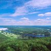
 Bull Shoals Dam and Lake
 Recreation and Sports
 Salmonids
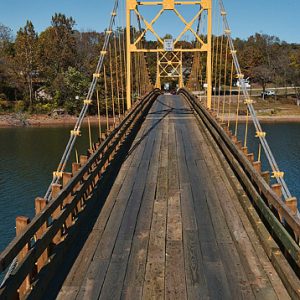 Beaver Bridge
 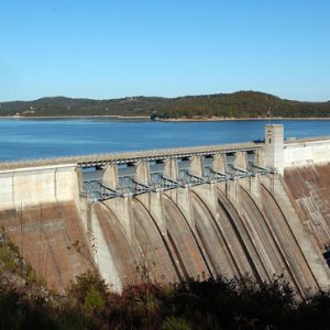 Beaver Dam and Lake
 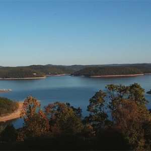 Beaver Lake
501-918-3025
calsfoundation@cals.org
calsfoundation@cals.org
Beaver Lake was created by Beaver Dam in Carroll County. The lake—technically a reservoir since it was created by a manmade dam in order to store water—is located on the White River in the Ozark Highlands region of northwest Arkansas. Approximately seventy-three miles long and a maximum of two miles wide, the lake reaches from Eureka Springs (Carroll County) roughly to Fayetteville (Washington County). About 450 miles of shoreline extend through three counties: Benton, Carroll and Washington. The multi-purpose project provides flood control, hydroelectric generation, water supply, and recreation.
While the possibility of a dam on the upper White River was examined as early as 1911, the first feasibility studies by the U.S. Army Corps of Engineers for constructing such a dam were made in 1929 and 1930. However, it was not until 1954 that Congress passed a flood control act authorizing its construction. Several original proposed sites for the dam were determined to be unsuitable. One of these was near Beaver (Carroll County), a town named after 1850s settler Wilson Ashbury Beaver, hence the name of the project. The Corps of Engineers chose a final location a few miles upstream near Busch on river mile 609 in Carroll County.
The 2,575-foot-long dam consists of a 1,333-foot-long concrete section keyed into a limestone bluff, 1,242 feet of earth and rock embankment, and three small earth and rock dikes that fill gaps between adjacent hills. The spillway section is 328 feet long. Maximum height of the dam above the streambed is 228 feet. Mean depth is fifty-eight feet, and the maximum depth is 216 feet. The structure contains 780,000 cubic yards of concrete and 1.6 million yards of rock and dirt embankment. Storage capacity is 1.95 million acre-feet, which includes flood control storage. At full conservation pool, or normal managed lake level, the reservoir covers 28,200 acres with a shoreline of 449 miles. The mean hydraulic retention time (the time it takes for water to cycle through the reservoir) is one and a half years.
The first construction funds were included in a $1.1 billion public works appropriation bill in the fall of 1959, which contained construction and planning funds for flood control, navigation, and reclamation projects for all fifty states. The bill was vetoed by President Dwight Eisenhower even though it was trimmed in committee by two and a half percent at his request. Eisenhower had objected to Beaver Dam because of uncertainties over marketing the hydropower from the project. The Southwestern Power Administration had reported that the project was only marginally justifiable. Congress, however, overrode the president’s veto, and bids for the project were received the following year.
The actual construction process began in November 1960 with contract bids awarded to T. L. James and Company of Ruston, Louisiana, and J. A. Jones Construction Company of Charlotte, North Carolina. A groundbreaking ceremony was held on November 22, 1960, by the Beaver Dam Association. Congressman James Trimble (Third District) was the principal speaker. Governor Orval Faubus, Senator John McClellan, Major General William F. Cassidy (director of Civil Works for the Corps of Engineers), Clyde T. Ellis (former congressman from Benton County and then head of the National Rural Electric Cooperative Association), Joe Robinson (president of the Beaver Dam Association), and other local dignitaries also attended.
Bids for the construction of the powerhouse were opened in November 1962. Construction of the powerhouse and switchyard began in 1963. The turbine contract went to Newport News Shipbuilding and Dock Company of Newport News, Virginia. Two 77,400-horsepower Westinghouse units sit atop the turbines, each capable of generating 56,000 kilowatts. Power generation began in May 1965. The overall project was completed by June 1966 at a cost of $46.2 million. The reservoir reached normal operational pool in 1968.
Beaver was one of the first Corps of Engineers reservoirs in the country to provide for municipal and industrial water supply. This additional use was authorized by the Water Supply Act of 1958, provided a local sponsor could be found to pay for the extra storage capacity. The cities of Rogers (Benton County), Bentonville (Benton County), Fayetteville, and Springdale (Washington County) agreed to buy water from the newly formed Beaver Water District, which paid a share of the cost of the project. As of 2009, four water districts utilize the lake.
Unlike earlier projects in Arkansas, the Corps only acquired flowage easements around the White River. As soon as the federal Beaver Land Office opened to acquire land for the reservoir in October 1959, developers began to buy and sell property around the proposed lake. Out-of-state investors were quick to buy large acreages that could later be subdivided. By and large, Beaver reservoir is known as a residential lake. Situated close to the cities of northwest Arkansas, the lake area is home to many people who commute to work.
The Corps maintains twelve recreational parks on the lake. A trout fishery below the dam runs for the first seven miles before the river begins to enlarge again into Table Rock Lake. A portion of the fees collected at the parks and from Corps leases goes to local county governments annually as payment for loss of taxes on inundated property.
Enthusiastic fishing reports published in newspapers and national outdoor magazines contributed to interest in the new lake. One newspaper article dubbed Beaver “Queen of the White River Lakes.” It was promoter Ray Scott, however, who first brought the lake to prominent attention as a fishing destination. Scott held the first modern bass tournament at Beaver on June 5–7, 1967. The lake also hosted the Walmart FLW Tour from 1997 until 2009. Other recreational activities on Beaver Lake include hunting, water skiing, sail boating, and scuba diving. One of the state’s largest conservation areas (over 12,000 acres) is also adjacent to the lake—the Hobbs State Park-Conservation Area. A visitor’s center at the park opened in 2009.
The construction and maintenance of Beaver Dam has not been without technical challenges. A large cavern a few hundred feet upstream of the dam site was discovered during initial excavation work and was filled with 200 cubic yards of grout material. The earth embankment also rests on the Price Mountain fault line, and the dam underwent seepage repairs from 1989 to 1994 at a cost of about $33.5 million.
During fiscal year 2004, the Corps estimates that the White River lakes prevented an estimated $67.2 million in flood losses. Of that total, Beaver reservoir prevented $7.2 million in flood damages.
For additional information:
Beaver Lake. U.S. Army Corps of Engineers, Little Rock District. http://www.swl.usace.army.mil/Missions/Recreation/Lakes/Beaver-Lake/ (accessed March 16, 2022).
Beaver Water District. https://www.bwdh2o.org/ (accessed March 16, 2022).
Black, J. Dickson. Beaver Lake Area—Past and Present. Rogers, AR: Timberwolf Publishing, 1979.
Putthoff, Flip. “Quenching a 30-Year Thirst.” Morning News of Northwest Arkansas. October 14, 1995, p. 1B.
Water Resources Development in Arkansas. Dallas, Texas: U.S. Army Engineer Division, Southwestern, 1995.
White River: A Valley and Its People. Rogers, AR: Rogers Historical Museum, 2000.
Scott Branyan
Rogers, Arkansas


Comments
No comments on this entry yet.